
(Note: See my April 2018 article for an update on fishing the Faka Union River.)
The Faka Union River, known as the Fiki Uni to some long-time locals, is an important fixture of one of the largest pristine areas in Florida—the Fakahatchee Strand. It is the retreat of flocks of wading birds, deer, black bears, and the endangered Florida Panther. You may even see, as I did, an endangered American crocodile in this wilderness that has

been designated by Florida as an Area of Critical State Concern. And the chances for a coveted angler’s slam–snook, redfish, and tarpon–are as good here as anywhere in the country. I’ve scored several over the past few years. You may even hook a hungry bull or black tip shark to boot.
Although not apparent on the surface, the environment here has been severely altered by get-rich-quick development and drainage schemes over the past 50 years. Only in the past decade have serious remedial efforts been undertaken. The Port of the Islands development, the aborted Southern Golden Gates Estate project, and Faka Union Canal just up the road barely a mile from the put-in are poster children for the carnage.The Canal, dug in the late 1960s and 1970s to drain land for development in the area, lowered the groundwater table by up to four feet in some areas and sucked water from the Everglades to the west, drastically altering the natural water flow to the south. The rush of freshwater into the area significantly decreased the salinity downstream in Faka Union Bay, decimating oyster beds and other ocean life. Slow progress is being made at great expense to begin filling in the over 800 miles of roads and 138 miles of canals gouged from the wetlands north of Port of the Islands.
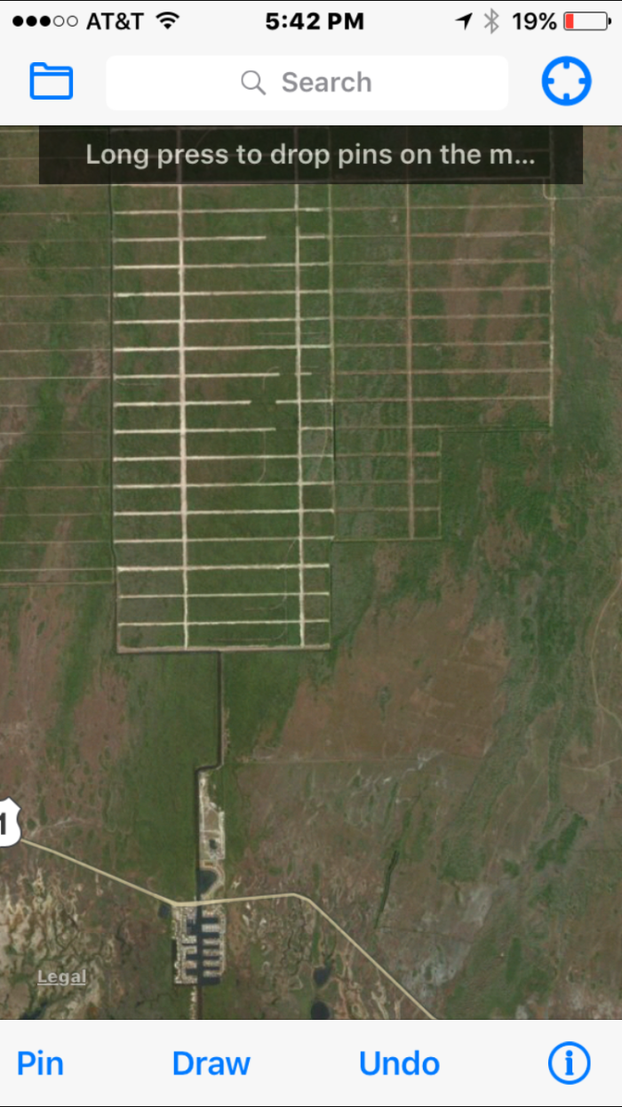
PORT OF THE ISLANDS, FAKA UNION CANAL, AND ABORTED LAND DEVELOPMENT
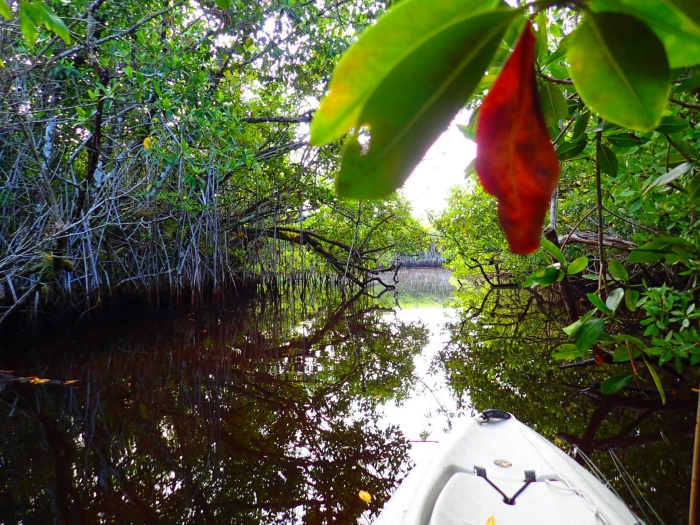
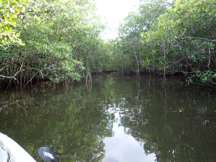
Fortunately, the Faka Union River has miraculously avoided much of the devastation except in its very lower reaches. The main stem of the Faka Union River and its two branches offer a myriad of intriguing and challenging fishing opportunities, from tight mangrove tunnels, to shallow mangrove-fringed flats, to hidden ponds where big snook find shelter. Four optional routes are described below, each with its own personality. Because of strong tidal currents and cramped, twisting mangrove tunnels littered with deadfalls, the North and Middle Fork routes should be attempted only by experienced kayakers.
Route Overview
The designated put-in for this trip is at Bridge 58 on the Tamiami Trail, approximately 1.1 miles east of the Port of Islands or 8.4 miles of the Highway 41/Highway 29 intersection at Carnestown. The launch point is on the south side of Highway 41 just east of the bridge and is marked with a canoe route sign. There is plenty of space for a vehicle and trailer with kayaks aboard to park. Do NOT follow the northern route described in Ripple’s 2003 Day Paddling guide to the Everglades–it is overgrown, too shallow, and no longer accessible. Look for a very narrow opening at the southwest corner of the mangrove forest ringing the put-in lagoon.
This will take you down a narrow, shallow, twisting mangrove tunnel for about 1/5th mile where the river skirts a broad prairie on its east bank. The waterway is very narrow at this point, crowded by the thick mangrove forest to the west. The going here can be very difficult, especially at low tide, and you may need to hop out of your boat and pull it through—but keep the faith. The bottom is generally firm, and in 500 feet or so you be back in a wider mangrove tunnel that soon emerges into the northern arm of the first in a chain of five lakes that dot the river to the south (at about 1/4th mile from the put-in). This first leg of the trip can easily take 20-30 minutes if the tide is low. (Note–The tides on this route are usually 2-3 hours behind the tides at Pumpkin Bay, the nearest gauging station.)
At low tide, the entry to the lake can be very shallow—stay to your right against the west shoreline—and you may have to portage over the firm sandy flats. At about 1/2 mile you will emerge into Lake #1, which like each of the five lakes described in the trip notes below, has some good fishing opportunities. A straight paddle southwest across the lake for 1/5th mile will bring you to a short mangrove tunnel leading in the large Lake #2. The western shoreline is deeper and easier to paddle, and after 1/4th mile narrows into a small bay that can hold some good snook and tarpon before pouring into a wide mangrove-fringed channel leading to Lake #3.
Lake #3 presents the first option to the angler. You can continue south to Lake #4 on the Main Branch of the river and access to the Middle Fork or veer to the west and paddle down the North Fork that snakes its way clear to the Faka Union Canal about a mile to the west and presents the opportunity for a loop trip that ends at the Port of the Islands Marina, a mile west of the put-in on Highway 41. The North Fork is an intriguing mixture of tight mangrove tunnels, hard sand flats, and deep holes that hold some good snook, redfish, and hungry snappers. At low tide, you will likely have to drag your boat over a large sandy flats at the entry to the North Fork. At low tide, much of the North Fork can be waded, towing your kayak behind. But beware, just around the first bend is where I had my too-close encounter with a six-foot American Crocodile, that was probably more scared of me than vice-versa.

The second option is to continue south which will bring you to a wide channel that connects to Lake #4 at about 1.5 miles from the put-in and then Lake #5, both smaller than the first three. At the outlet of Lake #5, the river flows down a wide channel that squiggles its way south for about 4/10ths of a mile to the confluence with the Middle Fork, which flies generally west towards the Faka Union Canal. This presents the third option to explore the Middle Fork which is wider and has a much stronger tidal flow than the North Fork. It offers a smorgasbord of fishing opportunities, even more than the North Fork, including an intriguing maze of smaller connecting lakes and ponds to the north. The distance from the Main Stem to the Faka Union Canal via the Middle Fork is about one mile.
The fourth and final option is to continue south from the confluence with the Middle Fork and continue on the Main Stem as far as time allows. The Main Stem narrows downstream from the confluence and then generally snakes its way southwest through a series of wide, beautiful mangrove tunnels. However, the distance to the Faka Union Canal—over 1.5 miles from the Middle Fork confluence, makes it too long for a serious fishing trip that devotes adequate time to the five lakes and miles of shoreline upstream, unless the angler makes a beeline from the put-in through those lakes to fish only the lower section of the Main Stem.
Tackle Notes
I typically take two 6 ½-7 foot light/medium spinning rods with 2500 series reels and use a #30 flourocarbon leader. I always carry a shorter 6-foot rod that allows me to cast in the tight mangrove tunnels for snook that lurk there. Sometimes I will take a fourth rod—a seven-foot medium/heavy rod and a 3000/4000 series reel with a 30# wire leader, if I want to have some fun and tangle with the bull shark that invade these waters as the salinity increases later in the winter. Some of my favorite lures are a four-inch white Gulp curlytail mullet or white Mr. Whiffle curlytail mounted on a 1/8 ounce red jig head, a rootbeer-colored curlytail grub, a three-inch gold paddletail soft plastic on a jig head, a #14 Mirrodine hard bait, a Yozuri 3D Crystal minnow, and the old reliable Baby Zara Spook for surface action. If I am going to spend time concentrating on fishing the lakes, especially Lake #3, I will strap a poling pole on the side of my kayak that will help me access the very shallow shoreline flats where snook and reds often hang out.
Trip Notes (December):
It’s December and the days are getting short, so I am launching at first light so I can get a full day in and explore either the North or Middle Fork. When the days are longer in Spring, I often spend some time fishing the lagoon at the launch on both sides of the Tamiami Trail. I have caught some good snook on a popping cork/DOI shrimp lure in the past. But today I immediately head south into the mangrove tunnel that leads to Lake #1. I see some torpedo shapes pushing giant wakes in front of me and start to reach for my 6-foot mangrove tunnel rod, but then see they are some sizable alligator gar that I don’t want to tangle with! As the channel turns southwest, I roust a few small snook, but resolutely ignore them because the water is very shallow and the casting tough with all the overhanging branches. The tide is still coming in, so fortunately I have enough water to slide through into the northern arm of Lake #1.

My rods have been stowed horizontally in the boat to avoid being snagged by the mangroves, and now I unfurl them, check the hooks to make sure they are sharp, and get ready for action. In a few months, I’ll have my shark rod at the ready, keeping an eye out for the bulls that like to cruise the shallows leading to Lake #1. I cast along the mangrove-studded shoreline as the channel narrows, then curves back to the southeast into the body of Lake #1. I’m pitching a white curlytail on one rod and the Zara Spook on the other. I take a wide angle around the first point and cast the Spook up against the west shoreline. Something big immediately jets towards it and the water erupts. I have it on momentarily, then the line goes limp. Probably a big snook. Subsequent casts come up empty, so I continue west down the north shoreline, which is shallow but at high tide has enough water to slide by. A little creek flows in a few hundred feet down the shoreline, and I get a couple of strikes but no hookups. I make a mental note to see if I can hack my way through the mangrove tunnel at the mouth of the creek into the series of hidden lakes to the north that show up on my Google Maps satellite view. Tip: There are multiple opportunities on this trip to explore these small hidden lakes and ponds off the main route, some of which can be very productive.
Past the little creek mouth, I carefully work the west shoreline of the lake. On an earlier late January trip, I had shots at multiple shots at tailing reds here, but today there’s no action. Finally, at the entry to the mangrove tunnel that leads to Lake #2, I catch and release a couple of small snook hiding under the mangroves that put on an acrobatic display, bringing a smile too my face. As I float into the tunnel, I stow the longer rods and bring out the six-footer. This tunnel is very tight, but always produces snook, sometimes some good ones. My first few casts come up empty, but I get a hard strike in a deep hole just before the tunnel opens into Lake #2. I quickly pitch my mushroom anchor overboard and pull over to the side against the mangroves. Then I toss a backhanded cast into the hole, let curlytail sink out of sight, and start a jerky retrieve. Immediately it’s slammed by a decent 22-inch snook that cavorts around the tunnel. Luckily, I keep him away from the mangrove roots and bring him to the boat. For the next 10 minutes, it’s a strike on every other cast and five more snook to the boat, all smaller than the first. A fine start to the day.
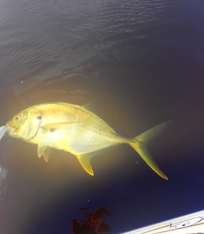
The mangrove tunnel opens into a wider, but very shallow channel where I steer to the west to avoid the sand flats. At lower tide I usually have to portage here. Around the bend, I angle towards the north shoreline where the water is deeper. Often I see bull sharks cruising the shallows here, searching for an easy meal, but not today. The river spills into Lake #2, and I hook a good two-pound jack crevalle on the curlytail where the current eddies out and creates a deeper hole.
Now I have a choice—continue along the shallow north shoreline or probe the deadfalls along the deeper west bank. Because the tide is till coming in, there’s enough water along the north shoreline which can produce some big snook and reds. I go that way. A GPS satellite view will reveal the distinct drop-off along the north and east shorelines where reds and sharks often chase plentiful bait. The drop-off is slight, only a couple of feet, but can be very productive. I caught one of my largest upcountry reds here, pushing 30 inches, on the Zara Spook. Today I come up empty, but see what looks to be a large snook blasting bait up against the shoreline. The water is too shallow to get up close, so I pitch the Spook up against the mangroves with a long cast. I come up empty again…and again. Resolved to being shut out here, I let the light southwest wind push me slowly towards the west shoreline. The water is three-four feet deep in the middle of the lake, and I pick up a couple of small snook on the gold paddletail.
The west shoreline has a very fishy look, with lots of nooks and crannies in the mangroves and deadfalls to probe. I get a couple more small snook, then slide around a point west into a small bay that often holds snook and tarpon. I stay back from the shoreline as I circle counter-clockwise, because the fish usually lay up close to the bank under the mangroves. I also pitch a few casts up into the creek that spills out into the bay, but don’t see any fish in the clear water or get any strikes. I continue to work the shoreline to the west and get distracted by a handsome Little Blue Heron who is threading his way among the mangroves. They are normally shy, but this little guy doesn’t seem to mind my presence, so I pull out my camera and start the video.
Distracted, I immediately run on a 30-inch plus snook sunning in a foot of water a few feet in front of me. Naturally he spots me and rockets past the kayak into deep water before I can get a cast off. That’ll teach me. So I continue to film, and get some good footage. Then, just as I shut off the camera, I float right over another big snook, this one about two feet. He, too, jets off before I can make a cast. GRRRR! Maybe they’ll be back on my return route later in the day. At least that’s what I tell myself.
The little bay narrows into a channel that connects to Lake #3. It’s one of the most consistent stretches on the river, featuring a succession of deep holes and back eddies on the east bank that is fringed with overhanging trees and deadfalls. I usually anchor up on the west side of the channel on the shallow sand spit that leads into the channel, casting into the likely looking spots along the east shoreline. The current rips in here, so a good anchor is mandatory. At lower levels, it is possible to get out and wade. I aim my first cast carefully downstream and skip the curly tail under some overhanging branches. The hard strike is immediate, a nice 20-inch plus snook. Before I am done with the channel, I manage to boat 3 more that go 16-18 inches and miss that many strikes. A couple of hungry snappers round out the catch.

I slid easily into Lake #3, but the entrance is extremely shallow and may require portaging at low water, but the effort is definitely worthwhile. Lake #3 has consistently produced snook, jacks, and reds for me. The biggest including a 29-incher on a rootbeer grub with a chartreuse curlytail and a strong three pound jack on a #14 Mirrodine Mirrolure. I find the north shoreline and the middle of the west bay of the lake to be most productive. To add to the fun, when cooler temperatures hit later in the Winter, manatees enjoy the warmth of Lake #3 which is deeper than the others in the chain. Today I nail a couple of snook on the curlytail against the timber-studded south shoreline, but nothing of any notable size.
You will have the choice of an alternative route at this point. The shallow west end of the lake hides the entrance to the North Fork, a twisty turny option that is tough to navigate but a blast to fish. It flows about one mile to a fork where it splits and joins the Faka Union Canal in two spots. I often anchor up on the shallow sandbar at the entrance to the North Fork for lunch, then fish the nice hole just downstream for snook and snapper. On a low, falling tide it is possible to wade down the creek, making short casts into likely spots for snook, reds, and snapper. I find them typically hiding in the deep alluring holes at the big bends. This is much easier than casting from a kayak while trying to buck a strong current. However, it was at the first bend that a large crocodile lounging in the shallows put a big scare into me. Fortunately he jetted off faster one way than me in the other. Needless to say, I got back in the kayak before resuming the trip downstream, despite the conventional wisdom that American crocodiles are not aggressive.
The North Fork soon opens up into a series of wider small ponds and offers the opportunity to explore some hidden lakes connected by tight mangrove tunnels. I fish the deeper holes and back eddies carefully, and stretches just above and below the extensive hard sandbars that dot the river. My best fish was a two-foot red that was hiding in three feet of water next to a tangle of mangrove roots. Snook and snapper can’t resist a shrimp-tipped jig. Pay particular attention to the deeper holes at the fork of the river just before it meets the channel.
Today I take the second option, continuing down the Main Stem to Lakes #4 and 5. I get sporadic bites and catch a couple of small snook along the shoreline of these two little beauties, but have never had much luck in either. A good side trip for any budding ornithologist is the hidden lake that can be accessed off the west shoreline of the channel between Lakes #3 and 4 near the USGS water gauging station. It’s loaded with all manner of wading birds—storks, spoonbills, herons, and egrets.
Continuing south out of Lake #5, I cast the shoreline of the wide channel of the Main Stem without any luck, but at the deep hole that has been carved out as the river takes a hairpin turn to the west, I fool a couple of fat snapper and a baby snook on the curlytail, letting it countdown to the bottom. The sandbar on the inside of the bend is a good spot for lunch or an afternoon snack. Around the next bend, I spy a mangrove tunnel with a good outflow, and throw the curlytail up under the overhanging mangrove at the mouth. WHAM!! The water explodes as a nice snook inhales the lure and high jumps into the air. After a good fight, the fish comes to the boat, not as big as he felt—about 20-inches. But who’s complaining. I peek up the mangrove tunnel and gamble that I can hack through into the big horseshoe-shaped lake I can see on my GPS. The orb weaver spiders scurry away as I creek through the tunnel that emerges into the lake which is loaded with bait and surprises me with its depth—ranging from three-to-five feet, unusual for one of these side lakes. But despite the promise, I manage nary a strike despite some thorough work.
Back in the Main Stem, I glide around another big bend downstream and find myself at the confluence with the Middle Fork. The narrow opening into the Middle Fork belies how much wider it is than the North Fork, wide enough to be navigated by a small powerboat at high tide. The current is also much stronger, making it a challenge for a kayak when it is roaring in as is now the case. Without a pedal kayak, it would be tough to fish and deal with the current simultaneously. I work a couple of deep holes at the bends without any luck, then make the mistake of hurrying over a big sand flat to the next tunnel—I spook a big snook that’s out in the open in about a foot of water. He flies by me like a jet.
Having been singed once, I approach the next sandbar carefully and spy a nice snook feeding in the shallow flow, plainly visible. I cast fifteen feet in front of him, but something doesn’t look right and he hightails it into a deep hole downstream from the sandbar. Now I’m zero for two.
I’m heading generally west, and then the river makes a big bend to the south, which creates a deep hole and big back eddy off to the side. I pedal carefully into the upper end of the hole and pitch the curlytail into the current and let it sink out of sight. Nothing on the first two casts, but the third results in a jolting strike, and the fish bores deep. Feels like a big red! The fish pulls the kayak towards the mangroves before I can toss out the anchor, but I have my new Hobie peddle kayak with reverse gear which saves the day. I pedal hard, and the canoe shoots backwards, towing the big red away from danger. Before too long, he’s at the boat, posing for a picture, and on his way—a muscular 24-inch specimen.

It’s about 3:30 p.m. now, so time to head back upstream, especially if I want to fish a little secret, hidden pond that holds some big snook. Fortunately the current is still coming in hard so I’m whisked back upstream and at the confluence with the Main Stem in no time. I head downstream a ways on the Main Stem without any luck. It’s another 1.5 miles to the confluence of the Main Stem and the Faka Union Canal via a series of serpentine mangrove tunnels—too far to cover in a full day from the put-in on the Tamiami Trail unless you skip fishing in the chain of lakes.
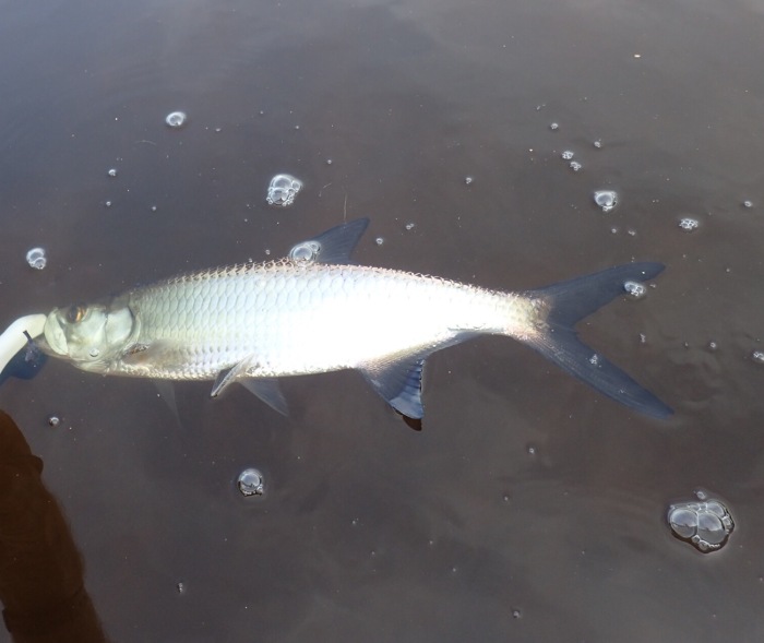
On the way back upstream, I catch an occasional small snook, but am doing more pedaling than fishing. When I get back to the bay in Lake #2 where I spooked the big snook earlier in the day. I work my way quietly along the west and north shorelines, but come up empty. I keep tossing the curlytail as I round the point into the main body of Lake #2 and something explodes on it. A tail-walking tarpon lets me know right away what I am on to. He makes several three-foot high plus jumps before coming to the boat—a nice two-foot baby tarpon! So I have my slam!!
But the day isn’t over, with the hidden lake still to explore. I paddle carefully through the short mangrove tunnel leading into this shallow snook hideway. At the mouth of the creek feeding the pond, something big pushes a big wake as it flees, but I can’t catch a glimpse. My first half-dozen casts come up empty, but as I follow the creek further upstream out of the pond, something crushes the curlytail in the narrow channel. My reel screams as the big snook tears for the mangroves. The bottom is too soft to bail out and pursue, so the kayak goes crashing into the mangroves, and the snook is snagged on a tangle of roots. I lean out of the kayak and am amazed to find she’s still on despite her desperate gyrations. I finally get the line freed, and the snook dives under the kayak and heads downstream, spinning the kayak around. Thankful I have a 30# test leader, I haul back and turn the big girl. Success! The beautiful fish with gold tinged fins goes 26 inches, one of my biggest of the year. Now I have a real slam to brag about–each of the three beauties over two feet long! She goes free just as the sun starts to set, so I set course for home.

On the way, just before I enter the long mangrove tunnel leading back to the put-in, I manage to fool another jack and a big catfish! I smile as an armada of long-nose gar lead me back to the launch as the sun dips below the horizon.


You are indeed the fishyest guy I know. Carry on. Happy Holidays. Omar
>
LikeLiked by 1 person
Chris,
I have been reading your blog for a while and really enjoy it. I have moved from Evergreen CO to Bradenton Florida to be close to family. I founded the Blue Quill Angler, a fly shop in Colorado in 1988 and my wife, Martha and I sold it this past January. Used to fish the Arkansas River but mostly the South Platte and Colorado. I am attempting to do some blogging but I find that fishing gets in the way but will continue. Am loving learning salt water fishing. I have a friend and past employee coming to visit me from Colorado in December. We are planning to go down and stay at the Port of the Everglades in December and fish the Faka Union River or other areas.. We will have 3 days to explore and fish. Do you think the hurricane has changed the ability to get into the area? Do you think there will be high water there in December? Are the bugs bad in December? Any advice you could give would be helpful.
LikeLiked by 1 person
Hi Jim. Thanks for the kind words. I definitely know the Blue Quill. Excellent shop—I have a hunch we must have met there at some point. Regarding the Faka Union and other upcountry creeks, I’m not sure what Irma did to access but she definitely rearranged the inshore landscape according to all reports. Touch base with Charles Wright at Everglades Area Kayak Tours for the latest. It might be worthwhile to get a guide the first day out to get the latest on access and conditions. Google Rich Jones who is one of the few local upcountry creek fishing guides. Water should be fine in December. The dry season is Jan-March. Bugs shouldn’t be bad but it’s all relative down there. Take 100% Deet in case the no-see-unscathed are hungry. I’ll be down at my place in Everglades City in late January. Keep in touch and we can hit the water together. BTW all my buddies say the inshore snook fishing is on fire. See my blog article on kayaking around Chokoloskee Island for some trip routes. Chris
LikeLike
Thanks for your response and advice I will contact Charles. I am really looking forward to seeing and fishing the Everglades. Will let you know how it goes in December. Your articles have inspired me to visit. Are you writing a book about the Everglades?
Jim
LikeLiked by 1 person
Yes working on a kayak fishing guide to the Everglades and Ten Thousand Islands. Look forward to your December report.
LikeLike