

“Run wild and free like a waterfall”
Anancha Mishra
Mid-September 2018
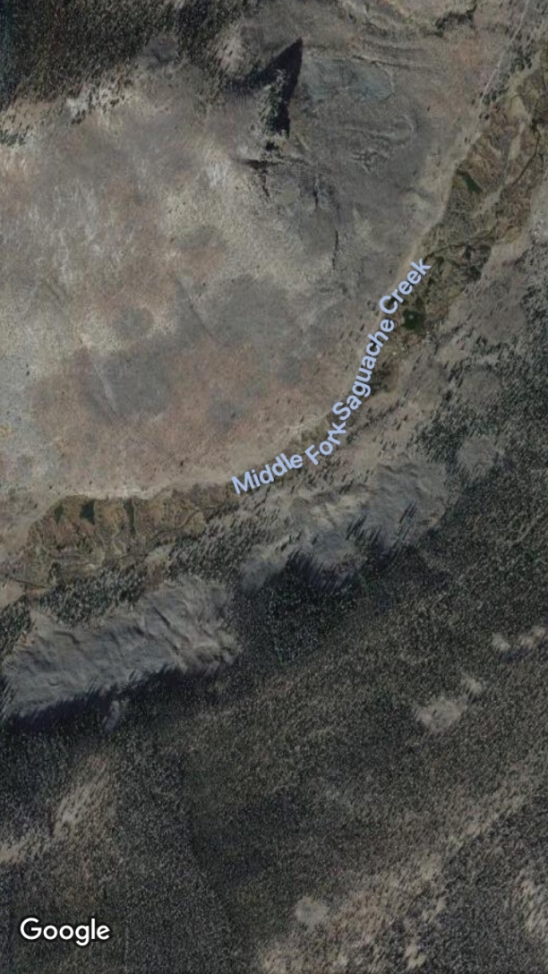
Waterfalls—especially backcountry ones—are like magnets to most people, including me. Now admittedly, while I love their scenic beauty, I plead to an ulterior motive: They usually create a series of deep plunge pools below that inevitably harbor some muscular trout. So when I read mention of a spectacular falls on a remote section of the Middle Fork of Saguache Creek high in the La Garita Wilderness Area, I vowed to make the trek.
Earlier this summer I had fished up about a mile from the Middle Fork trailhead, the gateway to the La Garita Wilderness area (See my July and August 2018 articles.), but it’s another three miles to the falls, and those pesky fish kept biting in the creek and beaver ponds, so didn’t make it very far.
Now an eight-mile roundtrip hike doesn’t leave much time for angling, which meant I needed to get a very early start if I was to make the falls AND get some fishing time in the creek and the series of alluring beaver ponds below the falls that showed up on my GPS map.
I am on my annual September fall fishing expedition with my mobile fish camp parked at the Dome Lake State Wildlife Area above Gunnison, Colorado.


When I wake, I know it’s cold outside, because the trailer heater has been kicking off and on all night. But I am shocked when I start up my SUV and the thermometer registers 19 degrees. Can’t be! I tap it, and it falls to 18! Mercy!! And my front window is iced over solid. Fortunately, my big industrial-sized window scraper is in the back seat, so it’s still a go.
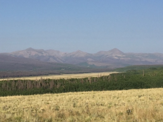
As I rattle up the bumpy, but passable road to Saguache Park over the Continental Divide, I notice a lot of camps scattered here and there in the woods. Later I will learn that it’s the start of elk and deer hunting seasons for bows and muzzle-loaders. I make a mental note to wear an orange blaze vest or orange hat next time to warn off the aspiring nimrods!
As I crest the pass into Saguache Park and drive past the old historic Salt House, I am treated to the sight of a big herd of antelope—20 or more. Always a good sign!
Then it’s past the Stone Cellar Campground/Ranger Station and up the Middle Fork Valley. I ford the creek about half way up and navigate the rough road towards the trailhead. I am surprised to see a couple of big hunting camps replete with canvas-wall tents and big travel trailers near the trailhead. I grind and gnash my teeth! Fortunately, I won’t see another angler or any boot marks on the creek all day long—and don’t have to duck any arrows or bullets.
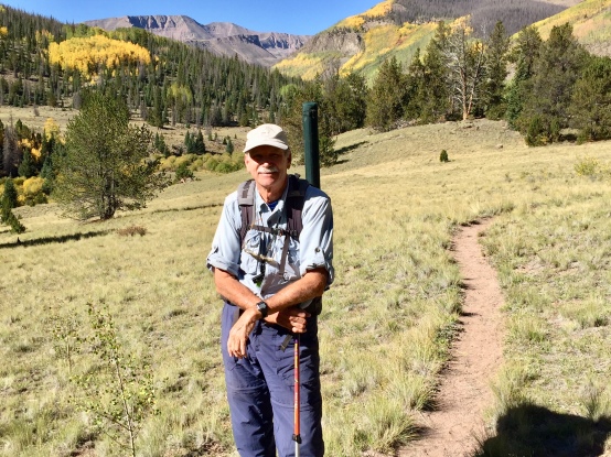
I finally reach the trailhead after about an hour and 15 minutes on the road, suit up, sign the wilderness registry, and hit the trail.
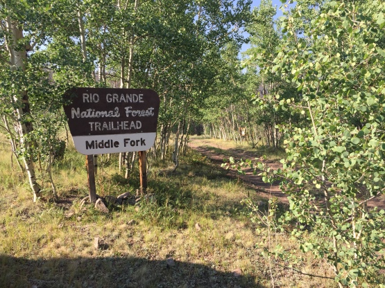
I am carrying a daypack loaded with a pair of lightweight wading boots, some waist-high waders, and a lightly packed fishing vest in addition to the full range of backcountry gear—rain jacket, first aid kit, etc. I decide to take only one rod stowed away in a case, a light wand at eight feet and five weight, great for casting in tight quarters. The creek is running very shallow as the drought here in Colorado continues, and it is unlikely I will need a second rod/nymph rig to probe deep pools. Just not enough water.
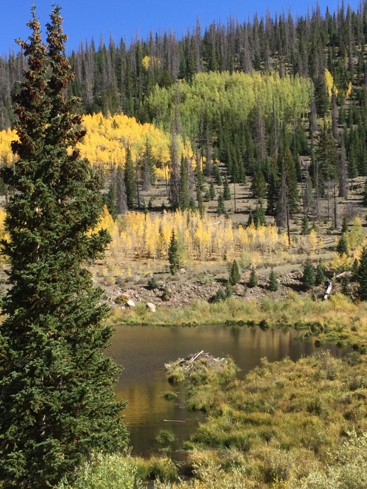
The Middle Fork trail is well-defined and only climbs about 600 hundred feet from the starting point to the falls which sits at about 11,000 feet. It’s a great hike with some moderate ups and down sections and requires only one shallow creek crossing near the start. The aspens are turning, adding to the pleasure.


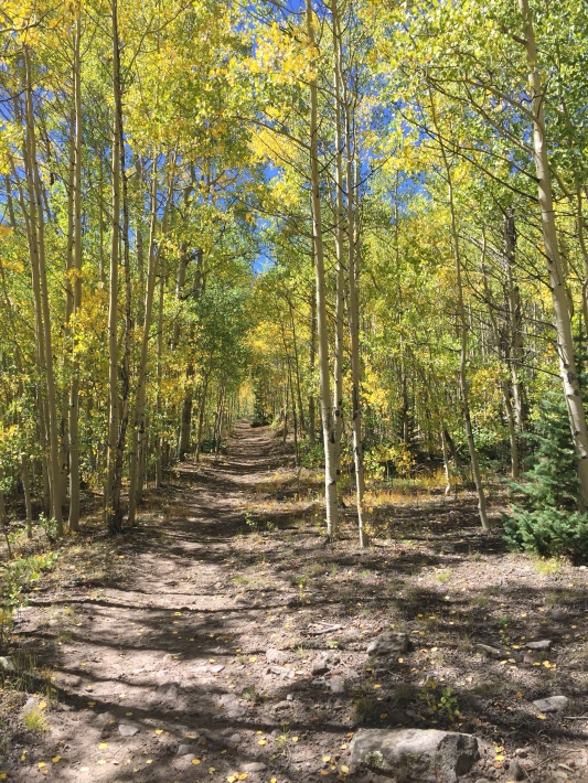
It’s hard not to stop frequently to snap some photos. The iconic, unusual Twin Peaks tower to the south.

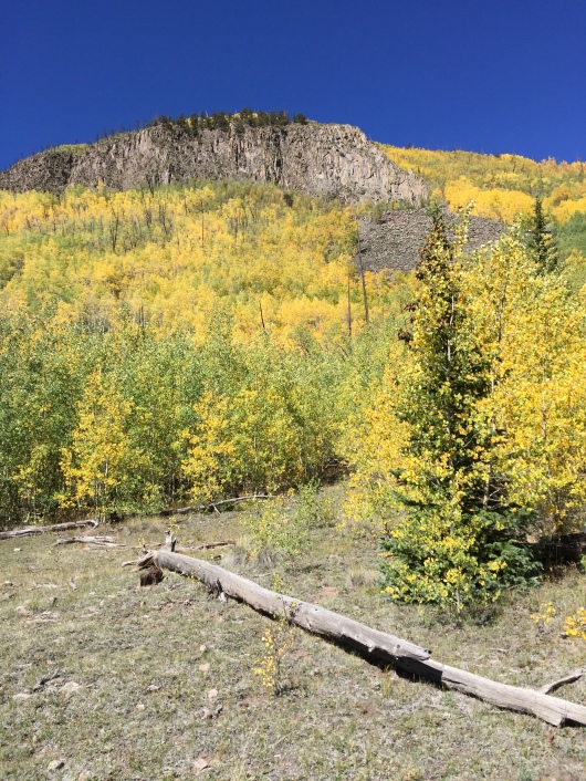
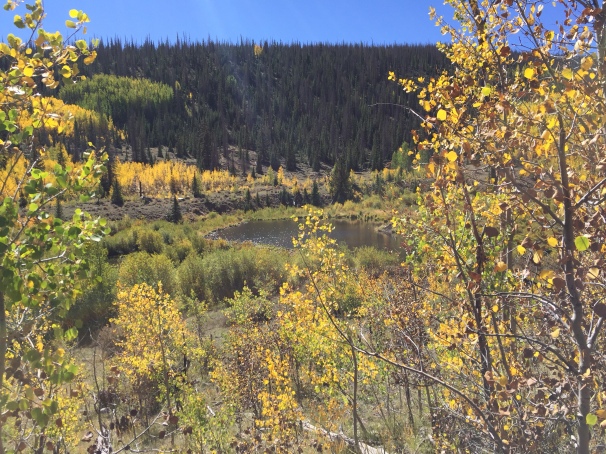
Ahead, the north slope of the valley shows signs of a big wildfire maybe 15-20 years ago, and huge stands of aspen have filled in all around the big burnt pine trunks that poke up here and there. Natural succession in action.
It’s even more difficult to resist heading down to the creek when it breaks out of the dense willows that line the water in many spots or where a beaver dam straddles the flow, creating some alluring ponds that are dimpled with risers. One caveat—wherever the trail splits, keep to the high ground above the creek. I get off the trail in one spot and end up bushwhacking through some especially dense and nasty willows before I come to my senses and navigate back up a steep slope to the main trail.
The temptation gets especially strong as I pass Spring and Halfmoon Creeks. There’s open water near both, and I have a hunch the fish rarely see a fly down there. But my USGS Quad map (Halfmoon Pass), shows a whole series of big beaver ponds just above Halfmoon Creek, so I keep on trekking. I should have checked my GPS! What I find is a whole series of blown out beaver dams with no water in sight. Unlike the dated USGS Quad, the GPS shows clearly they are dry meadows. But both maps show a second stretch of beaver ponds another mile up, so I keep the faith.
And when I reach them, I can see some good fish cruising the shallows. I take a couple of photos of the best ponds, and decide to continue onto the falls and catch the ponds on the way back.
At about three miles in, I pass a damaged sign that says U.S. Department of Agriculture. I figure this is the official wilderness boundary, although for my money the wilderness started back at the trailhead. Indeed, the area just on the south side of the creek is in the La Garita Wilderness Area from the get go.
As I crest the next ridge, I am surprised to see another hiker coming down the trail…and he is carrying a rod case. Aarrgghh! We exchange greetings, and I learn he is a USFS ranger who has been way up in the high country sampling some alpine lakes for the US EPA. I ask him how the fishing has been, and he smile, pulls out his cell phone, and shows me a couple of photos of some monster cutthroats. He proceeds to tell me that on the way down yesterday he fished some beaver ponds a mile or so above the falls. Some were barren, but he hit the jackpot in several that harbored these big beautiful fish. I know I won’t have time to get back that far today, but already start thinking about a return trip.
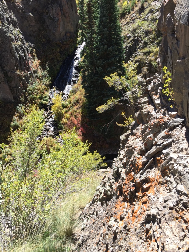
We bid adieu, and in a few minutes I start to hear the roar of the falls hidden in the canyon above. But unexpectedly the trail turns away from the creek and heads up the hill to the north, appearing to make a loop around the falls. I backtrack and find a faint path that angles off the main trail to the south and dead ends right above the falls. If I would have kept to the main trail, I would have missed the spectacular show unfolding before me.
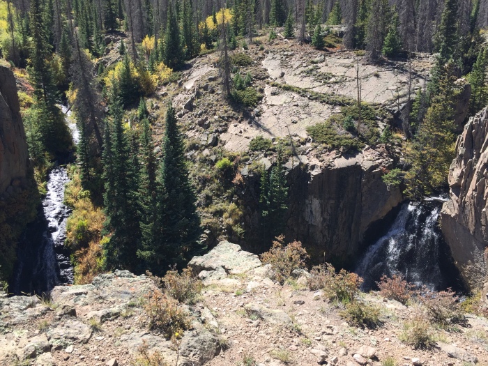
To my left, beautiful Benito Creek plunges headlong into the canyon floor, carrying almost as much was as Saguache Creek. To my right is mighty Saguache Falls, a breathtaking cascade. They join some 100 feet below me in a crystal clear pool where I can see a dozen or more lengthy torpedoes scurrying about. A twin falls treat, so unexpected!!
Of course now the question is how to get down there. I don’t fancy rappelling down the sheer cliff, but spy a little cut in the rocks that hides an extremely steep narrow gulch that descends all the way down to the creek just above the confluence.
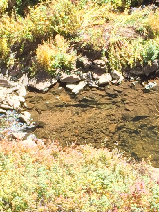
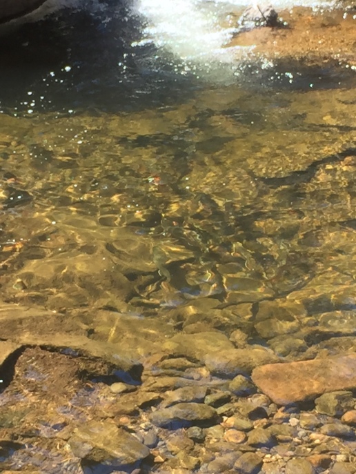
Now if I was sane, I would go back a quarter-mile downstream where the terrain flattens out and work my way up in the canyon. But time is getting short—it’s already early afternoon—and I just can’t resist. I drop my pack and put on my fishing vest, making sure my emergency satellite phone is in the big back pocket. Then using my wading staff, I pick my way gingerly down the loose scree, traversing back and forth while clinging to bushes to slow my descent. In ten minutes I am just above the confluence pool where I can see some big brook trout in spawning colors.
I work my way carefully downstream through the brambly rose and currant bushes and emerge just below the honey hole. I can see a dozen fish or more in the deep pool.
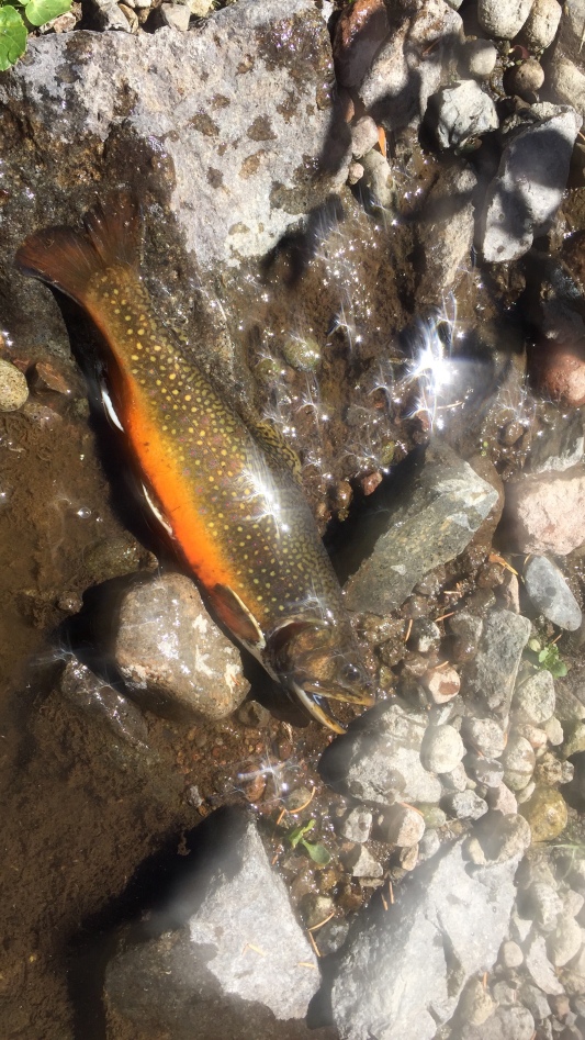
I cast from a crouch, and immediately something big nails the lime green caddis nymph dropper. All hell breaks loose as he makes his bid for freedom. The other trout in the pool stir up a frenzy, but I finally subdue the big boy. He is some outrageous spawning colors as he agrees to a quick pose, then scurries off to his girlfriends.
But the fight has put the rest of the fish down. I can see them huddled up in the deepest part of the pool, wise to my game. A dozen fruitless casts later, I decide to move upstream to the next pool, shallower but still looking deep enough to hold a fish. Righto!! On my first cast the Lime Trude dry is sucked under by another good-sized brookie. A couple of more quickly follow. When I think I have exhausted that pool I stand and promptly spook another five or six out of the hole.
Then I am up to the big waterfall. The spray treats me to a nice cooling shower, but it’s hard to see where the fish may be lying so frothy is the water from the tremendous sheet of water plunging over the rim.

I see a small patch of water off to the right that is a bit quieter than the rest, and thread my cast into it. The current swirls the fly this way and that, then it disappears. I set the hook and another colorful brookie leaps from the water. What a beautiful sight watching that little beauty fighting in and out of the gorgeous waterfall. In quick succession three more chunky brookies come to the net, two on the caddis nymph and another on the dry. Eight fish in 15 minutes—not bad!!


On the way a half-mile or so back from the falls, I note some good-looking camping spots for that return trip percolating in my head. I’m thinking a drop-camp with a local outfitter and horses so I could enjoy the luxury of a good-sized tent and plenty of food and libations. That way I could spend three-to-four days really exploring the waters below and above the falls, including the ponds that produced the big cutts for the USFS ranger.
Then another half-mile I come to the big beaver ponds I spotted on the trek in. In the first, I can clearly see a half-dozen decent fish finning in the shallows. I dump my pack and slink down the slope into casting position, a tricky spot behind some waist-high vegetation. I lob a short cast past the little school and immediately the biggest jets forward and nails the dry. Another good-sized brookie.
His antics spook his buddies, so I move carefully closer to the dam where I spot another bunch of brookies. No sooner does the fly hit the water and a decent brookie nails it. He soon comes to the shore, but now every trout in sight is fleeing to the nether reaches of the pond. I don’t relish putting on my waders and wading boots and mucking along the dam in pursuit, so head back up to my pack and down to the next pond a short walk down valley.
And just like in the first, the next pond is dimpled with risers. I repeat my sneaky approach, but this time the trout catch sight of me and flee in utter terror. Damn! I throw a long desperation cast but there’s nothing in sight in the clear water. Then all of a sudden, out of nowhere, a nice cutthroat glides over and sucks in the dry. After a nice tussle, he comes to the net and a quick pix.


Good one.
LikeLike
Thx Christie!
LikeLike
Another great read… great photos too. I gots to put that place on the list for next year.
Looking forward to the next post.
LikeLike
Thx Michael. Leave some fish for me!!
LikeLike
Just have to say that I miss the Honey Holes, Brookies, Brownies, and the beautiful September days.
Great stories and beautiful pics.
Makes one want to get organized and hurry to the mountains before ol man winter arrives.
PRS
LikeLike
Thx! Better get out here quickly! Leaves turning.
LikeLike
Great post and pics. Thanks for sharing. I fished those same beaver ponds, the ones you fished on your hike out, with my two boys. We spent one night about a quarter mile below the ponds. Ages 8 and 11, they did well with purple and red streamers. We’d read about Middle Fork in your prior posts…
It’s getting cold and snow is a possibility but I’m heading out tomorrow for one final solo overnight. My home base is the San Luis Valley so I’ll hit the South San Juan or La Garita.
Cheers!
LikeLike
Thanks Eric. Glad you were able to get up there with your boys! I’m hoping to get out again a time or two when it warms up later this month. Have you tried La Jara Creek this fall. Wonder if it has enough water? Stay warm if you go out.
LikeLike
I tried La Jara Creek early this summer. I suspect it’s real low now. If I get down there I’ll let you know. Have a great week!
LikeLike
Thx. How’d you do on La Jara earlier?
LikeLike
Honestly, not well. I recall one fish brought to hand. I did hit it at mid-day and it was really sunny out so probably not the best conditions. It’s probably worth a redo. Cheers!
LikeLike