(Near Canon City, Colorado)
Early May 2021
For my earlier articles on fishing Grape Creek see:
http://hooknfly.com/2017/11/08/going-ape-over-grape-creek/
Grape Creek is one of my favorite small waters in Colorado. It offers wonderful scenery and solitude along with eager browns and rainbows. I have been fortunate to have explored most of it from just below Deweese Reservoir near its headwaters near Westcliffe all the way down some 30 miles to Canon City. There are only a few public access points between Deweese and its confluence with the Arkansas River a short distance west of Canon City. Some of the roughest and wildest stretches are in Temple Canon just upstream of Canon City. I had a blast exploring scenic upper Temple Canyon in 2018 (See link above.), but my first attempt at sampling those hidden last few miles above the confluence had ended in frustration.
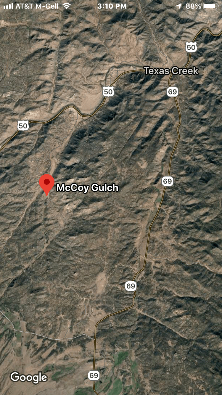
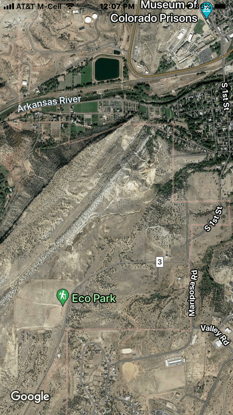
I was making the drive back from Denver to my cabin near Salida on a Sunday afternoon in early spring with notions of an outing on Grape Creek floating around in my noggin. Canon City was right on the way, and Google Maps seemed to promise easy access to lower Grape Creek up either Riverside or Grape Creek Drives on the south side of the Arkansas just west of town. To my chagrin, I soon found the hoped-for access near the confluence failed to note that both routes were blocked by private gated residential development. Not to be denied, I drove back towards town and over the Arkansas then up to Tunnel Drive trailhead, only to find more “no trespassing” signs posted by the railroad along the north bank blocking any access upstream to the creek. With my teeth grinding, I pulled out my cell phone and reconnoitered on Google Maps for possible access routes further upstream. The only possibility I could find was something called Eco Park, accessed via South First Street in Canon City then County Road 3. It was an easy drive out to Eco Park, but by the time I got there it was too late to attempt what looked to be a two-mile one-way hike to the creek. Lower Grape Creek would have to wait for my return.
Fast forward a couple of months and finally the weatherman forecast a day without snow, rain, or howling winds that had plagued my neck of the woods in late March and April, not to mention the so-called Arkansas Water Conservancy District finally decided to release more than a measly four CFS of water into the creek from Deweese Reservoir, which holds water for downstream irrigation by ranches and farms around Canon City. The low water levels had been further stymying my spring fishing plans for weeks. The water buffaloes who run the district had finally been releasing a steady 25 cfs for several weeks now, an ideal angling level. (Be sure to check creek water levels before your trip on the District’s web site or by calling Royal Gorge Anglers at 888-994-6743.)
I am suiting up in the Eco Park parking lot at 9:30 a.m. under sunny skies and with a gentle breeze blowing, all systems are go. A meadowlark is chortling melodiously nearby, his serenade almost always a sign of future angling success for this Kansas farm boy (Meadowlarks are the state bird.). I don my lightweight waders and get going, carrying a small lunch satchel and two rods. I start out on the good trail that accommodates hiking, biking, and horseback riders that will take me to the creek in about 0.8 miles. Immediately I come to a sign directing me south to Grape Creek, but I know from my on-line recon that I should follow the arrow towards Water Gap pointing me straight ahead due west. As far as I can see on Google Maps, the so-called Grape Creek trail goes nowhere near Grape Creek, and the Water Gap trail route provides the quickest and most direct access to the creek. Go figure.

The hike is flat and easy across a wide-open plain for the first quarter mile. I descend to a gate marking the start of BLM property and continue through it to follow the trail that loops to the right around a ridge and then turns back downhill to what is called the Water Gap, a narrow defile in jagged ridge where two ephemeral creeks have carved out a path to Grape Creek.


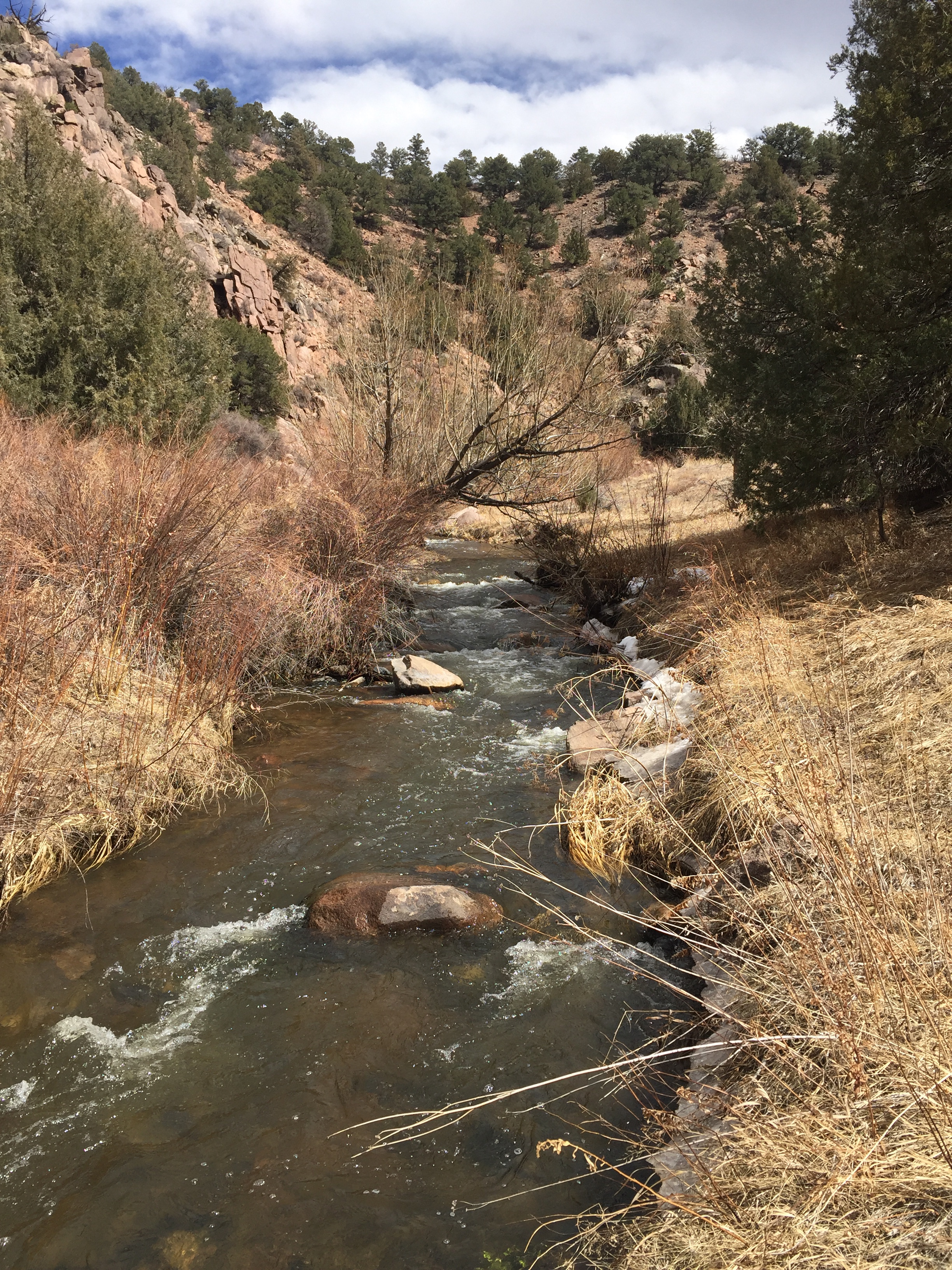
From there the trail follows a broad wash down to the water in another quarter mile. Sure signs of spring are everywhere, from the colorful flowers and buzzing busy bees to the leafy cottonwoods.


Temple Canyon and Grape Creek Canyon upstream beyond have a fascinating history. The intrepid explorer Zebulon Pike traversed the rugged terrain during the winter of 1806 as he explored the Great American West. He followed a trail used by the Ute Indians that led from the plains to their summer hunting grounds in what we now call the Wet Mountain Valley. Incredibly, in the late 1800s a narrow-gauge railroad line was carved up the canyon to tap the wealth of the silver and gold mines around present-day Silver Cliff and Westcliffe. But it operated for only a few years, landslides and washouts dooming the line. Remnants of this amazing feat can be seen today in the form of old bridge abutments and rock walls along the original rail bed. Workers in those bygones years discovered a spectacular natural amphitheater high above the creek that they dubbed the “Temple,” which became something of a tourist attraction.
Temple Canyon was transferred to the City of Canon City in 1912 by the federal government and today is managed to maintain its wild environment. The road from the city to Eco Park is paved, but beyond that to the Route 3 bridge over the creek is scary rough in places and twisty-turny, best handled by a 4WD vehicle. There are only a couple of primitive campgrounds for the hearty overnight visitor. No motorized contraptions of any kind are allowed in Temple Canyon, only leg-powered hikers. All of this is great news for the intrepid angler!
As I continue down the wash towards the creek I see a giant pipeline straight ahead. Turns out it is part of the irrigation diversion system that is sucking a lot of water out of the creek somewhere upstream. A hundred yards further on I see the result–Grape Creek is nearly dewatered, its flow barely more than a trickle and not a fish in sight in the crystal clear pools.


I had intended to stash my lunch here then hike downstream and work back up for victuals by noon then fish upstream in the afternoon. Now I am wondering how far I’ll have to hike upstream to find decent flows.
Fortunately, not too far. In about 10 minutes following a dirt road that goes upstream, I cross a bridge and come upon a concrete dam where at least half the creek is diverted into the big pipe.

I double check my two rods. The 8 ½ foot 4-weight rod is rigged with a #16 Royal Trude that imitates the many small grasshoppers I saw jumping about on the hike in and a #18 sparkle caddis larva that is a reasonable facsimile for the predominate creek insect. On the other, a 5-weight, 8 ½ heavier rod, I have tied on a #18 Tung Teaser followed two feet below by a CDC green hotwire caddis of my own creation that will allow me to plumb some of the deeper bend pools I expect to find based on my experience fishing upper Temple Canyon. I am using a 5X leader on both.
It’s been a few weeks since I have on the water so I decide to take a practice cast into the frothy pool below the dam before I work the long, deep pool above.

Immediately some small fish give chase to the dry, jumping out of the water in hot pursuit but failing to down the fake bug. Next cast the dry disappears, and I am onto a feisty trout that has taken the nymph, a little 8-inch rainbow that makes up for lack of size with a good battle.

Next cast the scene is repeated and another bow slides in to my net. I miss a couple more strikes then finally the fish wise up.
Now I’m primed and ready to hit the aforementioned alluring deep green pool right above the dam. I climb up the concrete structure gingerly, keeping a low profile and cast the dry/dropper. Surprisingly after a half dozen casts the trout are winning by a shutout. I switch to the nymph rig to probe depths where I can’t see the bottom, but the result is the same. I’m starting to think maybe this pool may get fished heavily since it is easily accessible.
Undaunted, I continue upstream. I see a few midges hatching, but no surface activity. I don’t see any boot marks and no broken branches along the shoreline, a telltale sign that it hasn’t been fished recently. Just around bend I come to promising run. It’s tight quarters, with overhanging tree branches in front and back of me. I carefully assess the situation and proceed to hang my first cast on one of the aforementioned branches to my rear. Fortunately I am 6’3” tall and can just barely reach high enough to retrieve the fly. The second cast is on target just off the main current, and as the dry dances downstream it disappears. I’m onto another pugnacious rainbow that has taken the caddis larva.

He’s a few inches larger than the first. That’s more like it. My next cast produces a small brownie.
A few minutes later I come to tempting run along a sheer cliff face.

Another small rainbow immediately nails the nymph. On the very next cast the dry again disappears, and I can tell I am onto something bigger. The fish dives and tries to tangle me on the beaver detritus in the depths. I work him slowly out and am rewarded with a 13-inch brownie that will be the biggest of day.

I continue working upstream where the brush thankfully recedes and the creek begins to open up. I get more frisky rainbows and an occasional brown. Most are 8-10 inches with a couple of foot-long browns. I’m a bit surprised that I am not getting anything bigger—in the upper reaches to Temple Canyon on my earlier trip I had shots at several fish that pushed 15-inches. A narrow trail parallels creek, and I start to see a few boot marks and wonder if more pressure here is the issue. Surely couldn’t be lack of piscatorial perspicacity or skill.
It’s pushing 1 p.m. now and with 15 or so fish to my credit, I pause for lunch in the warm sun and absorb the beautiful wild scene. Tiger Swallowtail butterflies are flitting about, and I can see some red cactus flowers blooming up on the steep slope above. The yellow buds of the cholla cactus are getting ready to burst.


After lunch I round a bend and come upon two huge dams—a beaver pond aficionados dream. I get a couple of small rainbows below the first dam and then see some rises near the left bank above so carefully scramble up on the dam and make a few casts. I don’t see any fish and no more rises. I gingerly wade out into the first pond which luckily has a fairly firm bottom and begin casting to the right bank where the current is flowing. I get several perfect floats but only manage to scare the daylights out of a sizeable brown trout that comes jetting downstream by me. My ego is salved when I pick up a couple more rainbows below the second dam on the dry fly.


Then I spot some movement in the cholla meadow along the stream—it’s two anglers in shorts with fly rods hiking back downstream. Hearty souls I think given the chilly water temperature! I also think the early birds get the worm (and fish). I toy with the idea of throwing in the towel, but decide to continue upstream where Google Maps reveals some beautiful bend pools. Happily I continue to get more steady action for small bows while managing to make things interesting with a couple of my patented long-distance releases on bigger fish.
By now it’s 3:30 and the sun is beginning to descend below canyon walls. But I just can’t quit. The serpentine creek reveals one tempting pool after another around each bend.
An hour later I have caught another dozen rainbows and browns and with shadows enveloping the pools and the air cooling quickly, decide to call it a day. It will take me an hour to get back to the trailhead. But there are still another two-plus miles of the creek I haven’t yet explored yet, the remotest stretches of Temple Canyon. I’ll definitely be back!