I’m pleased to report that the August/September 2021 issue of Florida Sportsman, in the “Hidden Gems” section, features my recent article about chasing exotic Peacock Bass in the freshwater canals of Golden Gate Estates with Guide Mark Rose and my fishing buddy Bob Wayne. See below to read or download the article:
I am always on the lookout for a new water to sample when making my weekly drive to Denver to do Grandpa duty with my little sweetheart Aly. I owe it to her for this latest discovery. I have had great days fishing some private water on lower Tarryall Creek below Tarryall Reservoir. But even though I have many times over the years zoomed past upper Tarryall Creek that flows under US Highway 285 just a few miles west of greater metropolitan Jefferson, Colorado, I never stopped to reconnoiter. It just didn’t look like much.
Now it’s mid July and I’m heading back to my cabin near Salida. Aly is with me, and I am excited about the prospect of her spending the entire week with me. We’ve already made plans to visit the alligator farm near the Great Sand Dunes National Park, do some lake fishing for rainbows, and swim in the relaxing pools at the Cottonwood Hot Springs. However, being a five-year old, patience is not one of her virtues so I have promised we would break up the three-hour drive with a lunch break near a “haunted” house I told her I spotted, on an earlier trip.
By “haunted,” I mean the big two-story historic but deteriorating Cline Ranch house visible from the highway near Jefferson. I pull off the pavement and follow the gravel road to a small parking lot. It’s odd, I think, because it only has four spaces, all of which are numbered. After lunch, I stroll over to a big sign next to the parking area and find out I have stumbled onto a state wildlife area that has not only preserved the historic ranch but also provides several miles of fishing on the upper Tarryall.
The story of how the ranch and creek were protected from development is not only fascinating but uplifting. It is the result of a great partnership among local, state, and federal agencies spearheaded by an old friend, Gary Nichols, the now-retired head of economic development and tourism for Park County. Gary was one of the most innovative public officials I had the pleasure of working with during my professional land use planning career. (For a good recounting of this ground-breaking effort, see parkco.us/650/Cline-Ranch.) While the preservation of the ranch and home was a big win for the public, just as interesting and creative is the English-style fishing “beat” system they installed for the long stretch of Tarryall Creek in the adjoining state wildlife area. The creek has been divided into four sections or “beats.” When you arrive at the parking lot, you park in one of the numbered spots, and that number becomes the beat that you have exclusive rights to fish that day and won’t see another soul on the water!! How’s that for solitude. Now the questions is, how good is the fishing??
Of course the ghostly tour is the first priority, and Aly has a great time peering in the windows of the main house and the outbuildings to see if there are any spooks about. Given the tattered, creepy appearance of the big home, which with its broken windows and peeling outer walls is in need of renovation, she is convinced that other-worldly spirits are definitely a possibility.
Ghostly Ranch House!!
But Grandpa is already silently planning a return trip for supernatural experience of another kind on the creek.
A couple of weeks later I am on my way to Denver on a Sunday morning and a little before 9 a.m. turn off US 285 into the state wildlife area. It’s a beautiful sunny day with the temperatures a pleasant 70 degrees, warm for the chilly climes of South Park. I had checked the creek’s water level before leaving home. It stands at about 20 cfs according to the nearby state water gauge, a level I find good for most smaller creeks. (See my article on how to access and read the state water stations at https://hooknfly.com/2021/07/23/how-to-find-stream-water-levels-in-colorado-a-primer/). I have chosen a beat upstream from the parking area, and after suiting up in my chest waders, begin to follow the faint ranch road to the north. The vistas of the mountains are spectacular as is the carpet of colorful wildflowers—skyrockets, wild garlic, and wood betony abound.
Skyrockets
Wood Betony
Wild Garlic
The history of this area is intertwined with mining. One story of how the town was named is that some prospectors on the way to digs in California took some time to tarry here and rest up. It is amazing how the land has recovered from the wild days of the gold mining rush of the 1860s. This was placer mining country, and the first wave of prospectors reportedly found gold flakes as big as watermelon seeds! Miles of the creek upstream were chewed up in search of more. After gold was discovered in Tarryall Creek and other nearby streams a few years later, the town located just upstream from the beat I was headed to, numbered some 3,000 residents with a full complement of saloons, retail businesses, a hotel, and houses. Today little remains. The town was actually the county seat for a while. Its miner residents also had `a reputation for being greedy and not selling parts of their early claims to newcomers as was reportedly the custom. As a result, Tarryall was sometimes referred to as “Graball.” Before long the newcomers moved on and started a town they called “Fairplay” as a slap in the face of Tarryall.
After snapping some photos of the striking wildflowers, I get back to business. But now I am starting to wonder exactly where my beat starts. Finally I see a small white sign in the distance to the west near some bushes, about where the creek should be. I head that way and am relieved to see it reads “Angler Access” with a faint path leading into a thicket of brush. After a little bushwhacking, I stumble my way onto some water. But it’s dead looking with barely any flow, certainly not the 20 cfs I expected.
Deadwater Creek??
I look downstream and see a small beaver pond, so head that way, making my way carefully through the tall grass. I’m carrying my four-weight, 8.5-foot rod rigged with my old reliable Royal Coachman Trude in #16 with a beadhead caddis dropper. I carefully come up from below the little dam and peer over into the pond. I don’t see any fish, but try a few casts that turn out to be fruitless. I mount the dam and continue wading upstream in the shallow water, but don’t see any trout at all. Damn, I think! I have been hoodwinked.
I decide to turn back to the road but as I do, hear the loud noise of what sounds to be a waterfall. I grit my teeth and turn west for some more bushwhacking, and low and behold soon find what turns out to be the main channel with the promised good flow. I look upstream and see several good-looking pools between fast-running stretches. Then the fun begins!
The Real McCoy At Last!!
In the first pool and on the very first cast a fish unceremoniously clobbers the dry, and I feel the tug of a good trout. Unfortunately my usual lightning-quick reflexes seem to have momentarily deserted me and I flub the strike, managing to prick the trout in the process. Fortunately he must have had a buddy close by because soon I am onto a nice plump and scrappy brown trout that also inhales the dry.
Let The Fun Begin!!
I continue upstream, and pick up another couple of brownies on the Royal Trude in the fast runs. But oddly when I get to the tempting deeper pools, I strike out, nothing apparently fooled by the caddis larva dropper. I double-check the creek rocks and find many more mayflies nymphs than caddis so switch to a #18 red Two-Bit Hooker that imitates the mayflies. That changes the odds, and I start to pick up some bigger fish subsurface
I’m having a good time when I come to a gigantic, six-foot high beaver dam with a huge pond backed up behind it. Fish are rising steadily all over—it looks like beaver pond nirvana.
Beaver Pond Nirvana!
I stealthily climb part way up on the dam and loft a cast towards one of the risers. He immediately inhales the dry and the fight is on. Second cast, same result.
But then things go dead. I get follows and nips at the Trude and dropper, but no connections even though the trout continue to rise up and down the long pond.
I flail the water a little longer, then finally decide the risers must be targeting small midges or mosquitos. I quickly substitute a #20 dark mayfly dry for the trailing mayfly nymph–a double-dry fly set up. Although microscopic, I can see the mayfly dry that sports a white foam top post for visibility as well as better floatation.
The Ticket!
With renewed confidence, I move up to the upper section of the pond. I spot a riser and drops a cast above the ring he’s created in the water. The trout attacks the little fly as if it hasn’t eaten in a week and puts up a worthy battle before sliding into my net. I definitely have punched the ticket as several more beauties quickly follow.
Beaver Pond Gold
The fast action continues for 11”-13” trout as I wade out into the pond and work the shoreline and then the inlet creek. I spot a good fish rising at the edge of deep run in the inlet creek 30 feet upstream just below where a rivulet drops its water into the creek. I kneel so as not to spook the fish I know are there and drop the flies in the current several feet above the pool.
Lunker Lair!
The two dries float into the deeper water and immediately a big trout slashes up and devours the little mayfly. It’s a big one, maybe pushing 15-inches. He runs downstream but I put the brakes on him, my rod bending perilously. He reverses course and heads back to the safety of his home pool…and the snags lining the shoreline. I run up the creek and try to head off the critter, but he makes it to a submerged branch at the top of the pool before I can turn him. Undaunted, I plunge into the deep pool, thankful for my chest waders. Miraculously, when I reach down and grab my line, I can still feel the trout gyrating about. I start to untangle my leader from the snag and just as I think I have him, the line goes limp. He’s broken off!
I retreat back to a nearby sandbar and rerig with a small black #20 dry and carry on resolutely upstream where I spy a beautiful foamy run along an undercut bank that looks promising. It lives up to its promise: I quickly catch and release three healthy, feisty brownies that are intent on getting into the snags that line the undercut shoreline. This time I am able to winch them away before disaster strikes and bring them to the net.
Pay Dirt On Promising Shoreline Stretch
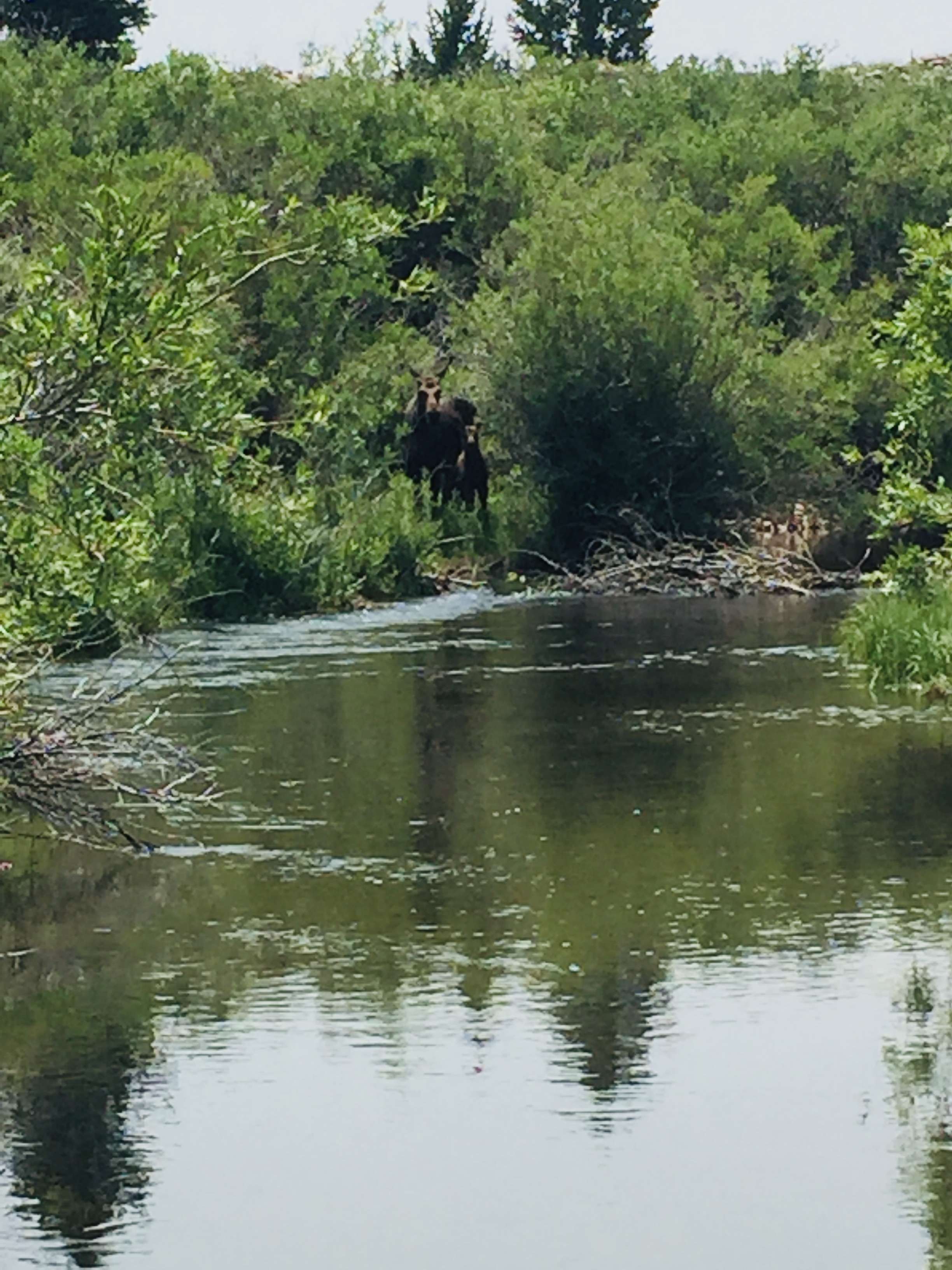
release the third one, I hear a branch snap upstream and look up to see a big moose within a stone’s throw staring intently at me. Then I see she’s with a calf. Anyone who has come face-to-face with a momma moose with a calf knows the next step is to look for a tree close by that one can scale quickly if and when she charges. I spy a likely candidate, but fortunately before I turn tail and run, she apparently decides a rickety old septuagenarian must not be much of a threat and ambles off into the brush with her offspring. Nothing like a close encounter of the moose kind to get the adrenaline flowing.
Close Encounter With Mama Moose!
I continue on upstream for another half hour, catching browns steadily all the way, most on the tiny dry trailer but several on the Trude in faster water. Finally my stomach is growling for an RC Cola injection so I pause for lunch on the banks of a big, deep pool at a bend in the creek. As I munch my lunch, I sit quietly and observe the trout that are rising sporadically. A couple that are feasting at the head of the pool in a tricky lie under some overhanging branches naturally look the biggest. Naturally!
Reenergized, I slide carefully back into the water and with a bit of luck drop an overhead cast just above the risers. Immediately there is a loud slurp and the tiny trailing dry disappears. Fight on! This skirmish is easier than the battle before lunch as the big boy shoots downstream for the alleged safety of the deep pool. But this gives me a lot of room to maneuver without any apparent submerged snags to worry about. Soon a muscular browning nudging 14-inches comes in for a quick release. I repeat the sequence and right on cue another good one gulps the tiny dry and succumbs after a good battle. Three more good brownies follow suit rising from the depths of the pool to feast on the tiny dry.
Big Bend Pool Pays Off
I continue upstream with steady action both on the Trude and his tiny companion in a sequence of alluring pools.
Then I run smack dab into another big beaver dam that I can barely see over. In the broad pond above I catch sight of risers here and there plus another big dam above that.
Reason To Return
But it’s going to take a high-wire act to scale and walk the dam then a slog through a mushy marshy shoreline to proceed above that. I check my watch and it’s 2 p.m. by now. I know I better be heading back to the SUV so I can beat the Sunday traffic returning to Denver that routinely clogs US 285. It’s a painful decision to leave this early, but there’s always later in the week when I return to Salida via the same route.
Now the challenge is to find a path out through the marshy terrain, thick brush, and tall grass back to the ranch road. I mush through the marsh then come to a side channel that’s flowing out of the upper beaver pond. I step in to test the bottom and promptly stumble on a big 15-inch brown trout that swims away insouciantly. After some false starts, I finally find a faint game trail that eventually leads me out without further insult or injury. On the way back I can’t but help pause to take more photos of the wildflowers and mountain peaks.
It’s been a rewarding day catching a couple of dozen healthy, pugnacious browns in only five hours. I’m glad I took my 4-weight rod to scrap with the muscular trout and that I wore my chest waders to navigate the beaver ponds. Now I can’t wait to sample the other three beats of Tarryall Creek
One of the recurring questions I get from my readers is whether the water is too high in such-and-such a river or is there enough water to fish now in one of the creeks you wrote about. A call to a local fly shop may provide the answer, especially for big rivers like the Arkansas. However, they often don’t track smaller waters. Fortunately the State of Colorado Division of Water Resources maintains a very useful online site that tracks surface water levels on literally thousands of rivers, creeks, and lakes that can help answer those questions. Here’s a step-by-step primer to help you figure out whether that water you have an eye on is fishable. I will use La Garita Creek, a tributary of the Rio Grande in the San Luis Valley, as an example. Obviously it will help to have direct experience on a stream at various water levels throughout the year to be able to gauge whether a certain flow level is fishable. That means you must do more on-site piscatorial research!!
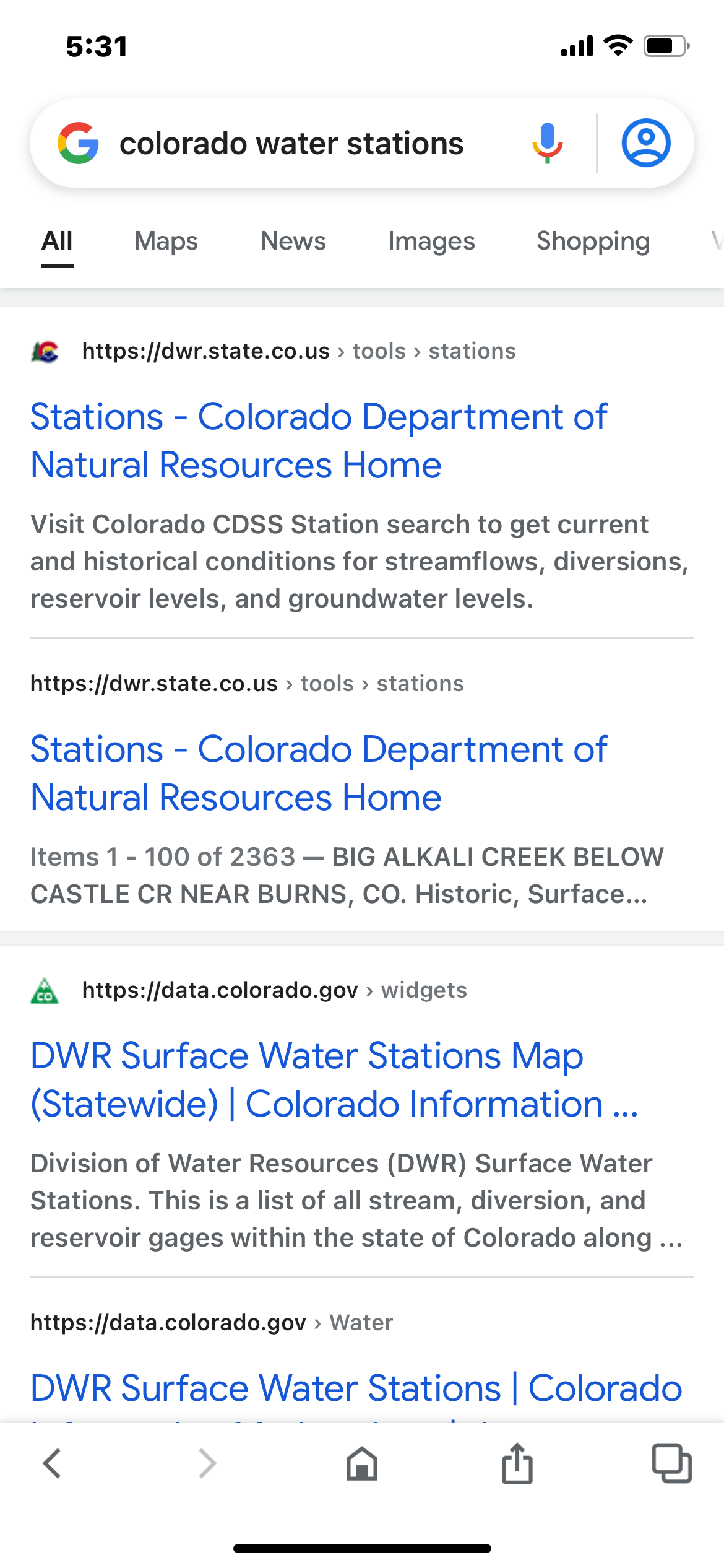
STEP #1: GOOGLE “COLORADO WATER STATIONS“
The first step is to find the Colorado Division of Water Resources surface water levels site. It’s easy: Just Google “Colorado Water Stations” and click on “Stations” at the top of the list.
Click on “Stations”
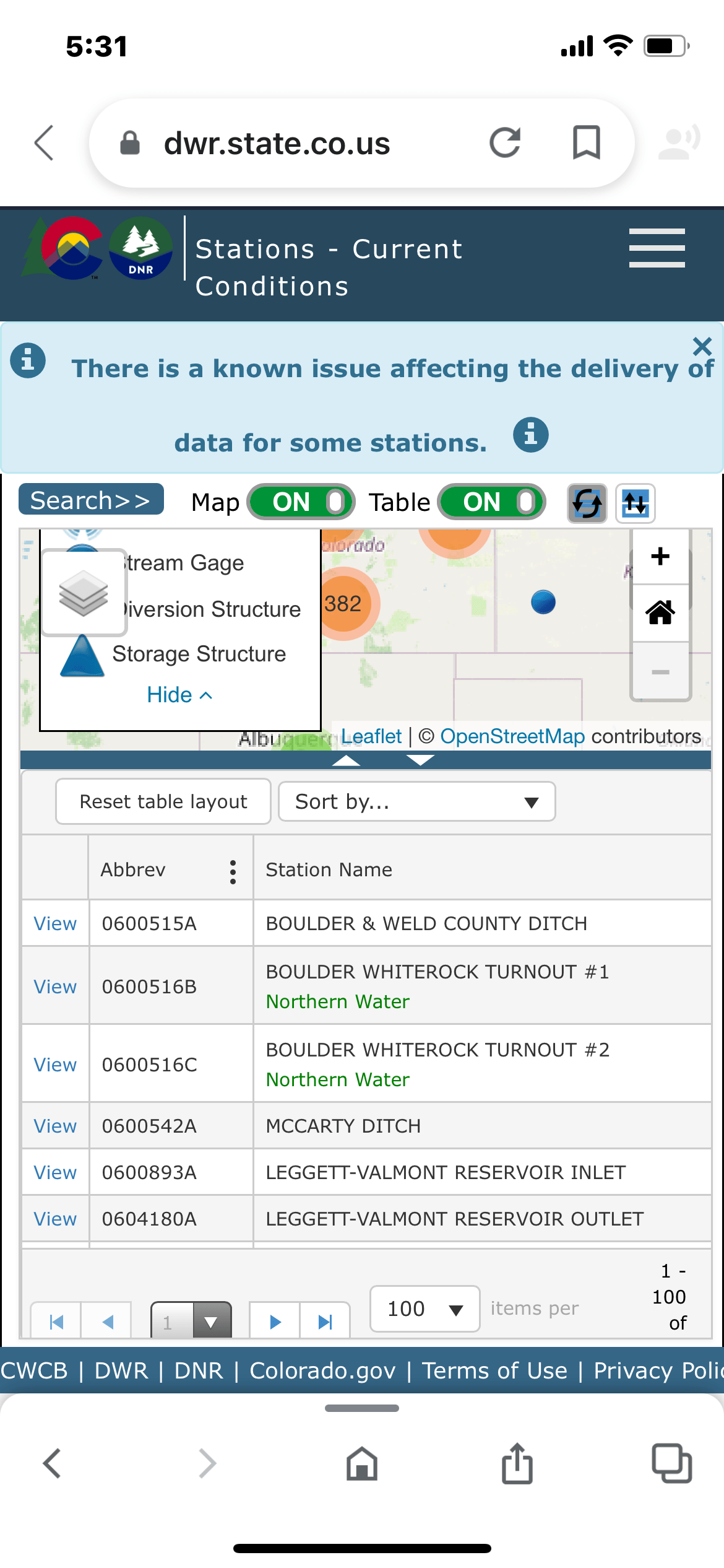
STEP #2: SEARCH FOR DIVISION (aka WATERSHED) LA GARITA CREEK IS LOCATED IN
The next screen will display every water in Colorado in the data base. To narrow your query, tap “Search” at the top of the screen.
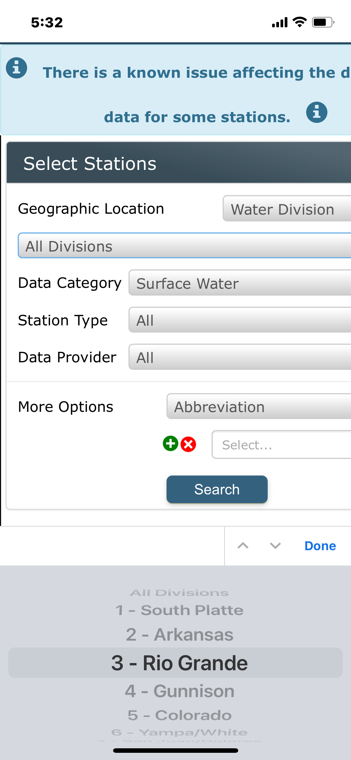
STEP #3: SELECT RIO GRANDE DIVISION
On the next screen press the search button near the middle of the screen and then select the Division in which the water is located. In this case it is Rio Grande River Division at the bottom of the screen. Hit “Done” when finished.
Select Division 3: Rio Grande
STEP #4: Scroll Down To La Garita Creek
A list of waters in the Division will be displayed on the next screen. The next step is to find the water that you want flow information on. In this case you can scroll down down to La Garita Creek near La Garita and press “View.” This will pull up relevant flow information on La Garita Creek. In some watersheds such as the South Platte there are over 500 listings so in that case you will need to specify how many waters you want listed to view.
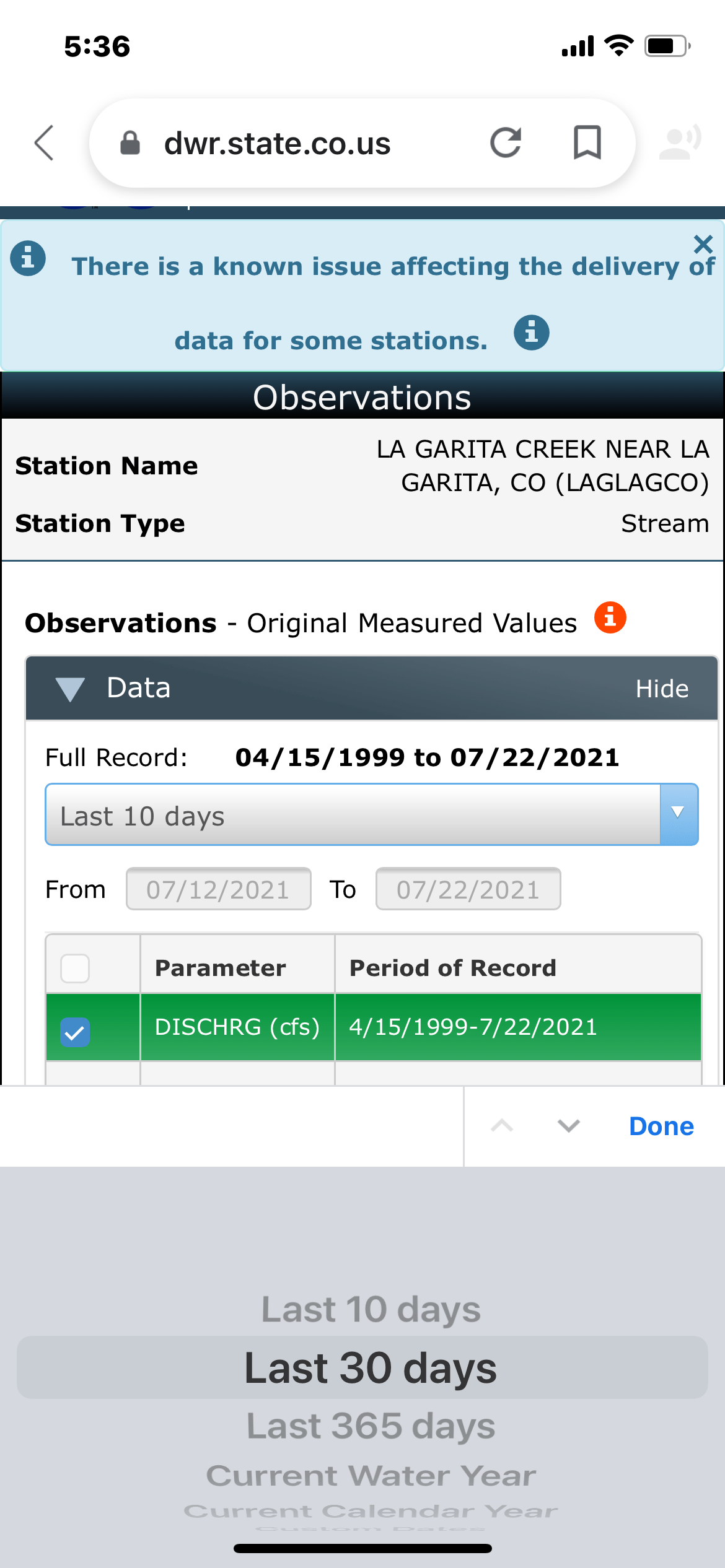
STEP #5: VIEW WATER LEVELS ON SELECTED WATER FOR THE LAST 10 DAYS
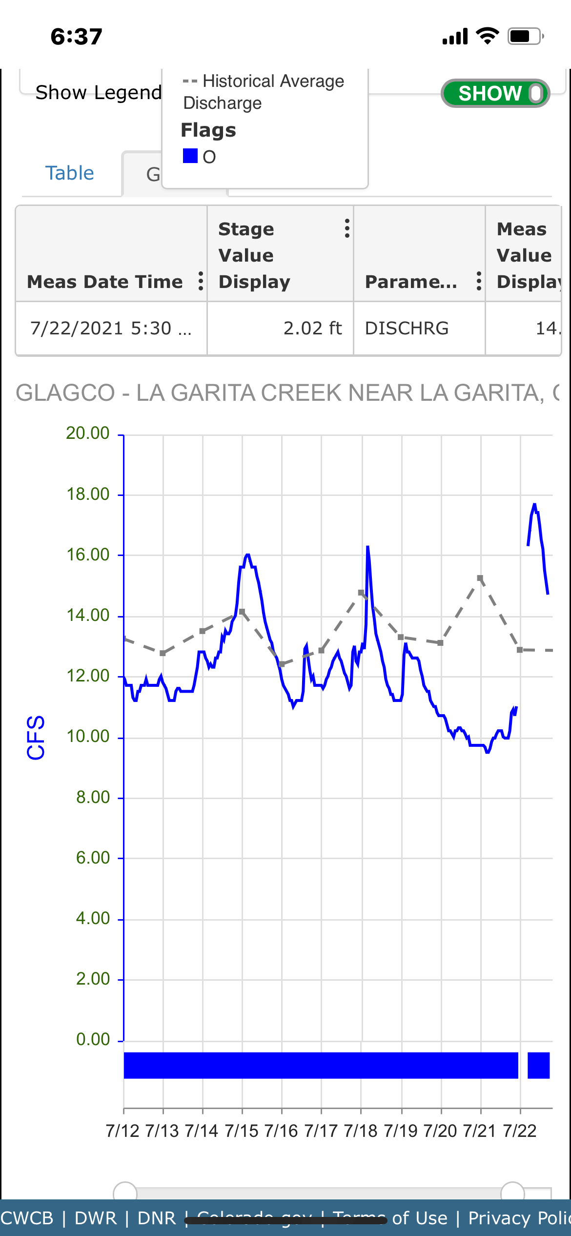
The next screen will automatically display the water level on the selected water for the past 10 days, both current and yearly average. In this case you can see the flow dipped to about 10 cfs before a recent rain added to the flow.
STEP #6: SCROLL TO TOP OF SCREEN AND SELECT “DATA” BUTTON TO VIEW WATER LEVELS FOR LAST 30 DAYS
Comparing water levels over a longer 30-day period can be useful especially in a period of rain or drought.
SELECT TIME PERIOD
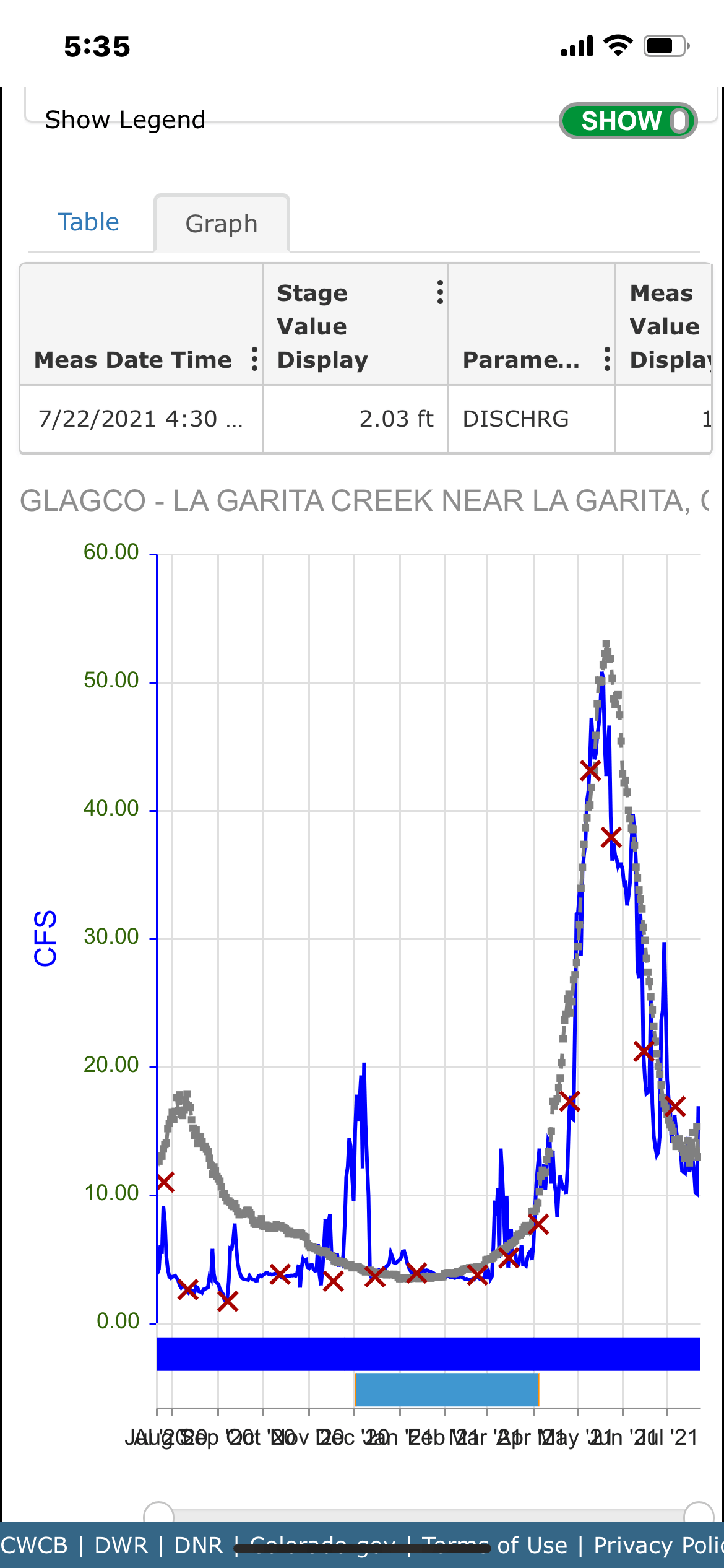
STEP #7: SELECT DATA FROM LAST 365 DAYS
Again, scroll to top of screen and select “Data” then select “365 Days.” Seeing average and current water levels for the last year will allow you to gauge whether the water is above, at, or below normal water levels. For most small streams a water level above 50-60 likely means it is not fishable due to high water flows. Water levels below 5 cfs are usually not fishable on most creeks. Note that even at a fishable level a stream may be turbid and muddy.
After two days of chasing trout on La Garita Creek featuring teeth-rattling drives down a rough 4WD road and some advanced bushwhacking, I am ready for something a little more easy on the old body. Today I have my sights set on Carnero Creek (Ram or Sheep Creek in Spanish) still remote but definitely easier to access.
This is my first overnight outing in 2021 with my little travel trailer/mobile fish camp. I have gone a little soft and opted to park it in the relative luxury of the venerable Woods and River RV campground in Del Norte, on the banks of the mighty Rio Grande. The temperatures are finally rising in the Colorado high country, the runoff is subsiding on a few creeks, and I’m itching to chase some trout on a couple of remote creeks that I recently discovered through some internet sleuthing—La Garita and Carnero on the western edge of the San Luis Valley.
Back in May I was searching on-line for some new small waters to explore not too far from my home base in Salida, Colorado, preferably ones that would call home for Rio Grande Cutthroats. Serendipitously, I stumbled on a U.S. Forest Service document that listed creeks in southern Colorado and New Mexico that harbored these beautiful, rare trout. All of the waters mentioned were small and remote, including two of my favorites—Treasure Creek and the Lake Fork of the Conejos River (See my article and blog about these two gems). Two I had never heard of—La Garita and Carnero–despite them being only a 90-minute drive from Salida and just over in the next valley from Saguache Creek, which I fish several times each year. To pique my interest even more, not only are they close to home but there was very little mention anywhere on-line about fishing Carnero Creek and nothing about La Garita. In fact I had to laugh when the only article that popped up when I search the phrase “fishing La Garita Creek,” were ones I had written awhile back about fishing Cochetopa and Saguache Creeks in the La Garita Wilderness which lies about 70 miles to the northwest as the crow flies.
So on a nice sunny day in late May I decided to do some on-the-ground recon on both creeks since they lay only a few miles apart. I liked what I saw on that day trip. While La Garita Creek was too high to fish, running at about 50 cfs, the angling prospects there were to my liking. Over five miles of the creek are on public land accessible by a rough 4WD road. The scenery is spectacular as might be expected of a creek named La Garita, which in Spanish means sentinel or overlook. Carnero Creek access was more civil on a decent gravel road. While Carnero was running a bit high and cloudy, there was plenty of water with public access I actually was able to wet a line on, catching about a dozen or so brown trout on the South Fork.
May Scouting Pays Off
I also spotted some promising stretches downstream on the main stem below the confluence of the South, Middle, and North Forks for a future trip. Unfortunately, I also discovered that the Middle and North Forks that reportedly hold only Rio Grande Cutthroats were too tiny to fly fish except in occasional beaver ponds. I plotted my return in June when the gauges on the state water level site showed them both falling to a more fishable 15-30 cfs level. (To find stream water levels in Colorado, Google “Colorado Water Stations” to access the Division of Water Resources gauging stations at https://dwr.state.co.us, then hit search to find the Rio Grande Division, then scroll to find the creeks by name and click on “view”.)
When the day arrived in mid-June with water levels falling rapidly, I hustled to load up my mobile fish camp and made a bee-line to the Woods and River campground in Del Norte the next morning. I set camp up at warp speed and by early afternoon was chasing some very cooperative trout on La Garita Creek. Now two days later I am heading out at 7:45 a.m. to beat the rain that is in the forecast. I’m on paved Highway 112 north out of Del Norte, Carnero Creek on my mind. I stay on 112 till it intersects US 285 where I turn north until I come to paved County Road G where I turn west towards the hamlet of La Garita. Just past La Garita (don’t blink or you’ll miss it), I turn north on County Road 41G which turns into a decent gravel road that snakes through several ranches until at about 5.5 miles the public lands begin beyond a narrows called Hellgate. From here until the confluence with the South Fork there are several stretches of public water interspersed with private lands.
Carnero Creek At Hellgate
Approaching Hellgate From The East
Soon I spot a turnout above a good-looking stretch of water and quickly suit up in my chest waders. I opt to carry one rod, my light 4-weight 8.5 foot outfit rigged with my old reliable Royal Trude #16 and a #16 beadhead sparkle caddis larva dropped about two feet below.
As I start walking upstream, I can’t help but wonder if I may be trodding the same ground that explorer John Fremont’s ill-fated fourth expedition in 1848-49 covered in search of a rail route over the Rocky Mountains. We know Fremont and his men made it as far as nearby Boot Mountain at the headwaters of La Garita Creek where a blinding snowstorm forced them to turn back in January south to Taos. Before reaching Taos in February, 10 of the 34-man party died of hypothermia, starvation, and exhaustion, and the body of one was eaten by his companions. Two others were killed by Ute Indians. Quite a contrast from the bucolic meadow carpeted with wild irises and wild golden peas I am traversing along the creek today.
Carnero Creek Above Hellgate
But all’s not that easy. I’m surprised to find that the creek that had looked so open from above is actually heavily overgrown for the first eighth of a mile or so. Undaunted, wherever I spy an opening I hop down to the water and try to flip my flies into likely looking pools while avoiding the overhanging branches. I attribute my flubbing the first five strikes to the odd casting angles, tight quarters, and the fact that I can see the trout rising to my fly which prompts me into striking too soon. Thankfully my ego is soon salved when a feisty 13-inch brown shoots out from under a snag and gulps the Trude so greedily that I can’t miss.
Feisty Brown Trout Breaks The Ice
To my great relief, the brush soon recedes, and I am treated to beautiful open runs through the wildflower-covered meadow. The brush still often crowds on one side of the creek, and of course if there is a good pool it often has a branch overhanging that calls for a tricky sidearm cast. But wherever there is some depth or slower water, I can be sure to find several brownies eager to please.
Open Water At Last!!
As I continue upstream, the fishing really heats up when I come to a series of log jams and small beaver dams that provide deeper pools and quieter runs, safe harbor for the fish.
Log Jams Provide Perfect Hideouts For Wily Brownies
When I finally take a break for a snack and to soak in the rugged scenery surrounding me, I have caught and released a couple of dozen scrappy browns ranging from 10-to-14 inches. (Ok, Ok maybe 13 1/2″).
As I lounge, I see some dark clouds starting to roll in just after noon, so I figure I better get back on the water. In the very first pool I quickly fool two trout, and as I fight a third, I hear a long low rumbling sound. I look up and see a very angry looking black cloud scudding over the big ridge to the west, and sure enough it begins to spit rain. I break out my rain jacket and keep right on casting, and the fish keep right on biting.
The rain abates and the sun tries to peek through, but more rumbles of thunder echo off the cliffs, which I take as my cue to hightail it home. I scramble back up on the gravel road, take one last look at the creek, tip my hat, and double-time back to my vehicle.
Hats Off To Carnero Creek!!
I manage to stash my gear and dive into the SUV about 1:30 just as the clouds let loose. Despite the fact I haven’t caught any Rio Grande cutthroats, I can’t complain. Carnero Creek is a sweet little water in a wild setting with eager trout. Can’t ask for much more than that…and I haven’t seen another angler all day to boot! I’ll be back to explore some more….lots of good looking water upstream on the main stem and South Fork.
NOTE: Carnero Creek was running at around 15 cfs on this trip which is a good level. By late July it was running at 5 cfs which would be too low to fish.
As I bounce down the rough single-track road searching for an open section to fish on La Garita Creek, Jimmy Buffet’s volcano song is running through my head. Just 28 million years ago one of the largest known volcanic eruptions in Earth’s history took place near here, between the towns of La Garita and Creede in southwestern Colorado. It was a supervolcanic event that dwarfed the more recent eruption of Mt. Saint Helens and even the giant volcano that created the massive Yellowstone Caldera. The caldera the La Garita eruption left measures in at about 22 by 47 miles!
This is my first overnight outing in 2021 with my little travel trailer/mobile fish camp. I have gone a little soft and opted to park it in the relative luxury of the venerable Woods and River RV campground in Del Norte, on the banks of the mighty Rio Grande. The temperatures are finally rising in the Colorado high country, the runoff is subsiding on a few creeks, and I’m itching to chase some trout on a couple of remote creeks that I recently discovered through some internet sleuthing—La Garita and Carnero on the western edge of the San Luis Valley.
The Upper Red Point Is Location Of Carnero Creek
Back in May I was searching on-line for some new small waters to explore not too far from my home base in Salida, Colorado, preferably ones that would call home for Rio Grande Cutthroats. Serendipitously, I stumbled on a U.S. Forest Service document that listed creeks in southern Colorado and New Mexico that harbored these beautiful, rare trout. All of the waters mentioned were small and remote, including two of my favorites—Treasure Creek and the Lake Fork of the Conejos River (See my article and blog about these two gems). Two I had never heard of—La Garita and Carnero–despite them being only a 90-minute drive from Salida and just over in the next valley from Saguache Creek, which I fish several times each year. To pique my interest even more, not only are they close to home but there was very little mention anywhere on-line about fishing Carnero Creek and nothing about La Garita. In fact I had to laugh when the only article that popped up when I search the phrase “fishing La Garita Creek,” were ones I had written awhile back about fishing Cochetopa and Saguache Creeks in the La Garita Wilderness which lies about 70 miles to the northwest as the crow flies.
So on a nice sunny day in late May I decided to do some on-the-ground recon on both creeks since they lie only a few miles apart. I liked what I saw on that day trip. While La Garita Creek was too high to fish, running at about 50 cfs, the angling prospects there were to my liking. Ove five miles of the creek are on public land accessible by a rough 4WD road. The scenery is spectacular as might be expected of a creek named La Garita, which in Spanish means sentinel or overlook. Carnero Creek access was more civil on a decent gravel road. While Carnero was running a bit high and cloudy, there was plenty of water with public access. I actually was able to wet a line on, catching about a dozen or so brown trout on the South Fork.
May Recon Trip Pays Off
I also spotted some promising stretches downstream on the main stem below the confluence of the South, Middle, and North Forks for a future trip. Unfortunately, I also discovered that the Middle and North Forks that reportedly hold only Rio Grande Cutthroats were too tiny to fly fish except in occasional beaver ponds. I plotted my return in June when the gauges on the state water level site showed them both falling to a more fishable 15-30 cfs level. (To find stream water levels in Colorado, Google “Colorado Water Staions” to access the Division of Water Resources gauging stations at https://dwr.state.co.us, then hit search to find the Rio Grande Division, then scroll to find the creeks by name and click on “view”.)
When the day arrived in mid-June with water levels falling rapidly, I hustled to load up my mobile fish camp and made a bee-line to the campground in Del Norte the next morning. Quickly I set camp up and by early afternoon am heading northeast out of Del Norte on paved CR 112. Soon I turn north on Highway 33 that turns into a good gravel road. In seven miles it intersects with E39, a rougher but still passable gravel road that heads directly west paralleling La Garita Creek. It winds four scenic miles by ranches and second homes till it hits public lands. That’s when the fun and bumps begin.
I shift into 4WD and get ready to rock and roll. The single-track road starts out tamely, but then alternates between fairly smooth dirt sections and rocky, teeth-rattling stretches.
Into The Wilds–Don’t Be Fooled By That First Easy Road Stretch
It should not be attempted except in a high-clearance, 4WD vehicle with AT-rated four-ply tires. Trust me on this. Also, I would avoid it after a good rain as it crosses several deep washes. Aside from that it’s a piece of cake. My goal is to find a stretch that is not completely overgrown, of which about 80% of the creek is, making fly fishing virtually impossible there.
In a couple of miles I come to a sign announcing I am entering the Little Garita Creek State Land Board property that is open to public use.
I am a little confused at first, but soon figure out the road continues to follow La Garita Creek with its little tributary veering off to the north.
Several Fishable Stretches On The Creek Can Be Found Upstream of the State Land Board Sign
Finally a ways up the road from the sign I spot a wet meadow dotted with wild iris where I can actually see the creek. Bingo! I will find that meadows like this one are a good sign as apparently the streamside brush can’t grow so thick because of all the wet ground the iris love. I make a mental note of the spot and keep 4-wheeling up the road, which becomes increasingly worse and overgrown. A couple of time I have to veer off the road that is narrow and hard to navigate because of overhanging tree branches and follow some tracks through adjacent meadows then navigate back on the road.
Wet Meadows With Wild Iris Often Mean Open Water On The Creek
In a few miles I enter a ponderosa pine forest where the terrain is more open and spot a couple more fishable stretches. At about 5 miles from the start of the public land, I come to a creek crossing that is too fast and deep to attempt by myself alone in the middle of nowhere. While lower than in May, La Garita Creek is still running at a healthy 25 cfs.
I retreat a mile or so back downstream to an open stretch and suit up in my chest waders, anxious to get in the cold creek water as the temperature is pushing 90 degrees with very little wind. I’m in the creek by 3 p.m. checking under some stream rocks to see what the trout might be dining on and find them loaded with green cased caddis larvae and dark mayfly nymphs. There are also some caddis flies flitting about and as a nice flight of mayfly spinners dipping and dancing above the water. On my 8 ½, 4-weight fly wand I tie on a bushy #16 Royal Coachman Trude to imitate the caddis flies as well as the small hoppers in the meadow and a #18 green sparkle beadhead caddis larva about two-feet below it. The action is fast from the get-go and continues that way for the rest of the afternoon. I soon conclude they haven’t seen many faux flies lately. Indeed, I won’t see another vehicle or soul and no boot marks either today or tomorrow when I return.
In the first promising pool above a beaver pond I quickly net two spunky browns that attack the flies without hesitation, one on the dry and the other on the caddis.
Let The Fun Begin
I work upstream a few feet and spy a beautiful pool at a bend in the creek. Looks like the liar of a big trout….and it is. I cast up into the riffle above the pool and watch as the Trude bounces down jauntily. Suddenly a big trout, maybe 15-inches, appears out of nowhere and intercepts the dry, but I yank the away from him before he clamps his jaws shut and miss. Luckily the fly hook didn’t sting him, so I get a second try. Again the fly floats down into the bend pool and again the trout rises boldly alongside of it and nonchalantly sucks the Trude in. Whoosh! I sweep the rod back and set the hook, immediately and feel his weight, and just as quickly execute my patented long-distance release. I contemplate committing hari-kari, but decide to try again, beyond all hope. Alas, although the fly floats over the same spot again, this time the big fellow refuses to make an appearance. But just a few feet below against the bank, another sizable trout, this one around 14-inches, nails the dropper. But I miss again and pricked him with the hook so now he’s off his feed as well. I have to laugh at my ineptitude. Fortunately my ego is salved on the very next drift through the pool as a nice 12-inchers nails the dry at the tail end of the pool, and in the run just upstream where I catch and release three brownies in quick succession.
Lair Of The Big Brownies
Third Fish Is the Charm
That will be the pattern for the rest of the afternoon. In every bend pool or quiet stretch off the main current or behind a boulder, I can count on several strikes and catching at least a couple of fish. It becomes ridiculously easy, making up for all those times in previous years when the finny buggers have outwitted me.
The fishing really gets interesting when I come to a couple of big beaver ponds. I work the deep current in the middle of the first and lure a couple of feisty brownies from the depths.
Beaver Pond Bonanza
Out of the corner of my eye I see a good rise just below the next beaver dam. I sneak up and get into casting position on my knees, then pinpoint my cast between two bushes on either side of the current.
Another Big Trout Lair
The dry floats about five feet below the bushes and my jaw drops when it is sucked under by a tremendous swirl in the water. Unfortunately, the fish that made that giant swirl missed the fly! I try again, and again there is a huge swirl and another refusal. Clearly the biggest fish of the day has been toying with me. Then all goes quiet. I proceed further upstream, doing a high-wire act to mount the big dam and cast into the current flowing down the middle of the pond above. The dry is abruptly jerked under and when I set the hook my rod bends perilously. The trout heads towards some shoreline bushes but I manage to turn him away from the snags. The fight goes on back and forth before the handsome brownie comes to the net.
I continue working upstream to the head of the pond where a small sandbar with brush on it cleaves the stream creating nice flows on either side. I wade out carefully to probe a fast run between the sandbar and far shoreline, keeping my balance in the soft bottom with my trusty wading staff. I flip a backhand, side-arm cast upstream, and immediately a mini-geyser erupts around the dry fly. I am onto another good fish.
Tricky Stretch Produces
The battler finally comes to the net for a quick photo and release, another 13-inch plus muscular brownie. Three more fish succumb to siren’s call of my flies in that run, then several more on the other side of the split.
It’s five o-clock now, and as I size up the next tantalizing pool and beaver pond above, I am thinking of those tasty dishes and Dos Equis amber beer at my favorite restaurant in Del Norte, Los Chavolos. To fish or not to fish more? The low, rumbling sound of thunder and a few flashes of lighting on a ridge in the distance make the decision for me.
As I walk up the slope to the road, I start laughing, feeling a bit giddy–and believe me it takes a lot to make a septuagenarian giddy. I have caught and released in the neighborhood of 50 fish in about 2 ½ hours and lost probably that many more. It’s been one of those flat-out fun days like I used to have in Kansas as a kid, catching countless bluegill in a local farm pond. Today the trout were where they were supposed to be, usually in numbers, and cooperative in the extreme, a tribute I think to their carefree, unschooled life in La Garita Creek. Who am I to complain?!?
Day Two On La Garita Creek
After a hearty Mexican dinner at Los Chavolos in Del Norte, I get a good night’s sleep and am back on the road at around 8:30 then trundling up E39 20 minutes later. Today I vow to slow down and enjoy the scenery and wildflowers on the way to fish the Little La Garita State Land Board stretch several miles below where I chased the trout yesterday. The bluffs, buttes, and ridges are spectacular under a blue-bird Colorado sky.
And the landscape is dotted with gorgeous white blooms of the soapweed yucca and the bright orange and red splash of Indian paintbrushes. It’s cooler today with a little more wind, a refreshing combination.
A mile or so into the State Land Board wildlife management area, I come to the open stretch I spotted yesterday. I am using the same outfit and flies—why trifle with success! I catch a several small brownies in the first two pools then come to a beautiful waterfall flowing cascading from a blown-out beaver pond. I score a couple at the foot of the waterfall, then move up into the wider flow above. The action is again crazy good from the get go. I catch and release five hard-fighting brownies from 11-13 inches.
The creek above the beaver pond executes a big S-bend, with each curve yielding several brownies pushing 13-inches. Above the upper bend a riffle plunges into a fast, deep run, and more willing brownies come to the net. For the next two hours it’s lights out again, with the trout favoring the caddis larva dropper 2:1 over the dry, although the dry seems to attract more of the bigger fish. The dry is clearly the best in faster runs where the trout slash out at light speed to nail the fly. A couple of browns push 14-inches and all are healthy and sleek.
Around 11 a.m. discover the hackle has been unceremoniously ripped off the Trude by some toothy brownie. I decide to keep right on fishing without changing flies, and the trout don’t seem to notice any difference.
No Hackle? No Worries!!
By 12:30 I’m getting hungry, and if on cue the bushes close in, making casting nearly impossible. Still in that last postage-stamp size pool below the midstream boulder three browns give me a nice bon voyage party.
Wicked Thicket….But Brownies Like That Little Pool
After partaking lunch back at the SUV, I drive leisurely back down the road, stopping to snap photos of the wild roses, blooming prickly pear cactus, mountain blue bells, and other wildflowers lining the drive and soak up the spectacular vistas.
Nature’s Bounty
It’s been another rare day on La Garita Creek. All the fish were brown trout—the cutthroats that are supposedly in the creek must be higher up. No worries!! Miles more water to explore.
When I get back to camp, I immediately contemplate soaking my right elbow in Epsom salts, hoping to ward off a debilitating case of trout elbow that such a prolific piscatorial day can produce. After all, there are glasses of wine to be hoisted in celebration, and Carnero Creek awaits tomorrow!