

October 2021
For an account of my earlier trip in the Sangre de Cristo mountains where I fished for big cutthroats in an alpine lake see:https://hooknfly.com/2020/07/25/return-to-sand-creek-lakes-revenge-of-the-skunked/
I’m off on my last camping/fishing trip of the year. Snow is already on the jagged peaks of the Sangre de Cristo (Blood of Christ) Mountains in the San Luis Valley, and colder weather will be rolling in next week.

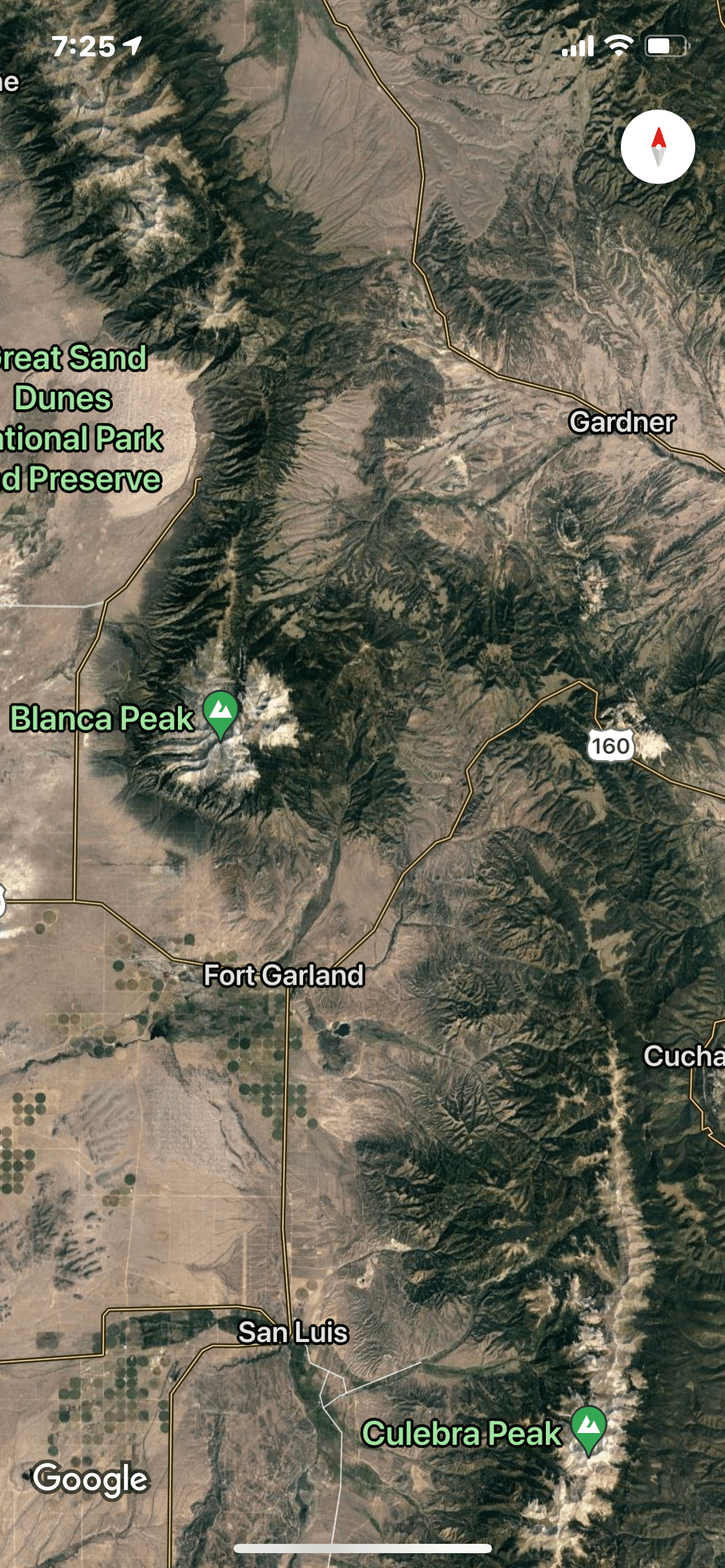
I have set up my mobile fish camp in an RV campground just outside of Alamosa, and have my eyes on two waters I haven’t yet explored in the remote high country of this imposing mountain range—the Huerfano (p. WEAR funno) River and Medano (p. MAY dunno) Creek. The Huerfano River lies on the east side of the Sangres in the southern reaches of the Wet Mountain Valley where it springs from the flanks of the majestic Blanca Peak, a fourteener and one of the highest summits in the Rocky Mountains. The second, Medano Creek, lies only about 15 miles away as the crow flies to the north of the Great Sand Dunes National Park on the west side of the Sangres. It is home to colorful, rare Rio Grande Cutthroats. While in close proximity on maps, the two waters actually lie a couple of hours apart by road.
The Sangre de Cristos are one of the most rugged mountain ranges in the United States rising abruptly over 7,000 feet above the valleys to the east and west, one of the steepest vertical rises of any mountains in North America. Nine of its peaks top 14,000 feet. Unlike the San Juan Mountains on the west side of the San Luis Valley that were created by volcanic activity, the Sangre de Cristo range is the product of tremendous uplift forces which helps to explain their jagged profile. Numerous alpine lakes and streams are hidden away in the deep folds between the soaring peaks. Hiking in this rough high country is not for the faint of heart as I can attest from an outing on Sand Creek lakes several years ago.
Doing my due diligence research prior to this October trip, I found very little mention of either water on-line, except occasional posts by intrepid hikers. I couldn’t find anyone at my local fly shop who had heard of, let alone fished either. Apparently neither is on the angling radar screen—my kind of streams!
Day 1: The Huerfano River
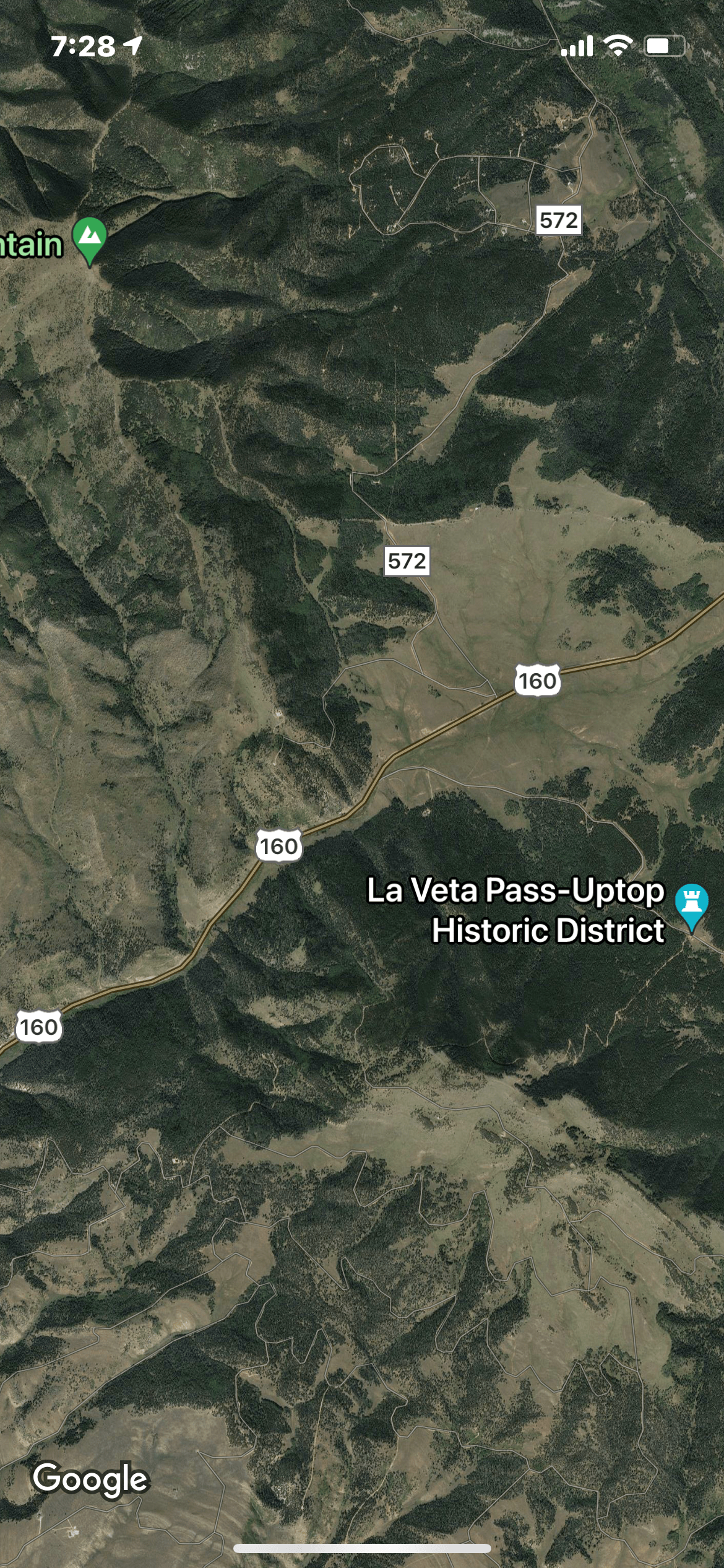
I’m up early the next morning for what will be a two-hour drive east of Alamosa to the headwaters of the Huerfano. It’s a pleasant scenic route on US 160 through historic Fort Garland to the turn off to the north on Pass Creek Road (Rd572) just before reaching La Veta Pass.

The gravel road starts out fine, the dust settled from a good soaking rain the past few nights. But then I start to run into stretches where the edges of the road are partially washed out where the rain cascaded through acres of burnt timber and denuded ground from a recent wildfire. I drive by some heavy equipment trying to repair the damage and am fortunate to squeeze by. Luckily the road soon improves, and I have to worry about dodging free-ranging cattle and occasional wild turkeys.


Rd 572 finally turns into Rd 570, and in a few miles when Rd 570 crosses the Huerfano River, I’m not surprised to see it is very low. This stretch of the river runs through a broad agricultural valley where its waters are diverted for irrigation. I figure I will find more water higher up. Rd 570 dead ends into Road 550, a paved highway where I turn left (west) and start up towards the headwaters.
The Hispanic heritage of the valley and agricultural lands to the east is reflected in the river’s name which means “orphan” in Spanish. The name comes from an iconic 300-foot high conical butte that stands alone by itself near the river in the prairie eight miles north of Walsenburg. This massive lone sentinel was an important landmark for early explorers like John Fremont.

In a few miles Rd 550, a paved highway, transitions into a good gravel road that winds up the valley and then through the narrow confines of the Huerfano State Wildlife Area. I get my first glimpse of the river and its rushing waters. It’s heavily overgrown, but has a better flow than down below as I had hoped.
Soon I come to a prominent warning sign notifying me that the next three miles are through private land and that trespassers will be shot and then shot again (or something like that). Now the road steadily deteriorates with some rocky, bumpy sections. I shift into 4WD, happy that I have four good AT tires and a high-clearance vehicle. I pass by a couple of mountain mansions, and then the valley opens up again. It’s hard to keep my eye on the road as the spectacular scene emerges, brilliant golden aspen framing the snow-covered east side of the Sangres.


But I’m jolted back to reality when I crest a ridge, and the road drops precipitously down the slope.

Road 550 transitions into Upper Huerfano Road 580 that is recommended for 4WD, trails bikes, and ATVs only. Rd 580 isn’t particularly steep but is pocked with big rocks and an uneven roadbed that require careful navigating.

Only in a few places does the road come close to the river, and then it’s mostly overgrown like below. I decide to keep going to the Lily Lake Trailhead where my map shows the trail intersecting the river in a broad open meadow. Finally at about 10:45 a.m. I reach the trailhead and am surprised to see four vehicles there, two that are average AWD passenger cars! I say a quick prayer for the drivers, hoping they have good 6-ply tires. It’s a long way from any tow truck.
I saunter over to the edge of the parking area, noting the remnants of a SUV running board being used as a fire pit bench.

I am greeted by a stupendous view of the river several hundred feet below in a canyon. The plunge pools look inviting, but only a mountain goat would dare descend from there. I hatch a plan to walk upstream on the trail then rock hop back down into the canyon.

I suit up in my normal high-country fishing uniform—chest waders, Simms Vapor wading/hiking boots, wading staff, and fishing vest loaded to the gills. I decide to carry only one rod, a lightweight 8.5-foot, four-weight wand rigged with a dry/dropper combo—a #18 Royal Coachman Trude for the surface and a #18 green beadhead caddis larva below. My leader and dropper are 5X.
The trail is in excellent shape thanks to the good work of a corps of volunteers according to a sign I pass. It ascends gently then descends into the big open valley promised on my map. The view is spectacular and will distract me for the rest of the afternoon—Blanca Peak and Mt. Lindsey in a magnificent cirque covered with the first snow of the season. I decide to veer off the trail and follow a game trail that wends through high grass down to the river.


As I get close to the river, I can see the water is low and crystal clear so I switch into stealth mode. I creep up to the shoreline, but despite my sneakiness, immediately spook a good-sized brook trout that zooms frantically downstream.


Ah, the vicissitudes of small stream fishing! My plan is cross the river in a shallow spot that I see 20 yards upstream then hike downstream through the brush on the east side into the canyon where I had spotted those alluring plunge pools–then work my way back up.
My plan works perfectly for about three minutes. As I wade across in the shallows, I can see a beautiful, deep pool at a bend in the river just above. Better yet, there is a school of brookies finning in the depths, apparently oblivious to my presence. I crouch to lower my profile and execute a dainty cast to the head of the pool just below where the current cascades in. I can see my nymph dropping down to the quarry that awaits. But the brookies don’t move a centimeter towards either fly. I try again, with similar results. Persnickety little devils. After a half a dozen skillful casts and floats later I stand to get a better look and send the trout into a fleeing vs. feeding frenzy. Oh well, I rationalize, I will deal with them later when I come back this way.
Then it’s off into the bushes and boulders above the creek to work my way into the canyon. The game trail I’m following soon runs into a nasty looking loose scree slope forcing me to cross over to the other side.

The streambed rocks are surprisingly slippery, but I execute my best nimble septuagenarian moves to emerge without a dunking. My sights are set on a tempting pool downstream. I creep slowly through the brush fishing a couple of little plunge pools on the way, one of which harbors a good-sized brookie who zooms to safety. When I get to the top of the target pool, I’m disappointed to find it’s very shallow and barren of any fish. I can see further below where the going gets even rougher, so decide there is plenty of water to work back upstream in the meadow.
I retrace my steps to below another alluring pool and am immediately captivated by the entrancing view.

I sit on a warm rock and soak in the grand scene for a few minutes. This moment is alone worth the trip I think to myself. The bonus is the four trout I see finning mid-pool in the current, one large one and three smaller. Then it dawns on me that they are in the pre-spawn amorous courting mode. I confirm my suspicious by executing several delicate casts which the trout respond to with zero interest. I decide to switch to a Parachute Adams with a 6X leader and add a #18 Two-Bit Hooker below on a 6X dropper. Same results. Clearly amore is trumping appetite.
Soon I am back to the pool just below where I started in the meadow. Five brookies are stationed in the depths of the pool. I kneel craftily and loft a cast above them. The flies drift perfectly towards the trout, but sadly, like their brethren, they show no interest in my offerings, so I switch flies again. I add a size #22 black zebra midge to the offerings. This has no noticeable effect on their obvious case of lockjaw. If frustration, I stand to size things up, which sends them jetting back and forth upstream and down in the pool in utter terror.
I continue upstream, hoping for better, but the results are the same. In a half dozen picture-perfect pools, the trout stick their noses up at my offerings while they swim around in romantic bliss. I take care to stay out of the water when I spot fish over gravel beds just in case some are already spawning. I spot one beauty that looks to be at least 14-inches, but like females of certain other species she won’t give me the time of day.

Next I try a long perfect looking run along the shoreline upstream that normally would be loaded with fish, but come up empty.
Toward the top of the meadow, the river splits, and I follow the east fork. I see a few trout here and there then come to a little beaver pond. A dozen trout are swimming in the pool created by the spillway, but I get too close, and they go flying downstream by me. Above the dam the river actually disappears, so I hike back downstream to find the other fork.

It is narrow and winds back west through the meadow and some marshes. Here and there I spot brookies lying up against the undercut banks, but can’t persuade them to bite.
It’s about 1:30 p.m. by now and my stomach is growling and patience growing very thin. I am beginning to resign myself to my first ignominious skunk of the year. Almost three hours of flailing the water and not a rise or bite let alone a fish. At least it’s been a scenic ecotour, and I have had the river to myself, nary a boot mark anywhere—just lots of sign of deer and elk! But wait, what about that good-looking freestone water back down in the state wildlife area I passed through in the morning ? That could salvage my reputation,
On the short hike back to the trailhead, I begin to plan my redemption. Without wasting any time shedding my boots and waders, I climb back into the SUV and roll downhill towards the wildlife area, a determined glint in my eyes. The scenery is again mesmerizing, blazing yellow and orange leaves capturing the afternoon sun, but I keep chugging along.

By 2:30 I’m back at the boundary of the wildlife area and find a nice turnout overlooking the river. I set up my folding chair and table overlooking a beautiful pool and partake of a hearty lunch and can of RC Cola power drink that helps me regain my mojo.

Below the turnout, the river bends away from the road and becomes invisible behind the trees and tangle of brush. I have a hunch that the hidden stretch doesn’t get much pressure, so walk down the road several hundred yards then plunge into the thicket. I follow a faint path that emerges just below a big boulder where a log has jammed to create a small plunge pool below it. I check the streambed rocks and find them loaded with caddis cases. I also see a few caddis flies flitting about in the air.
I tie back on the Royal Trude and caddis nymph and probe the pool carefully, but the current is much swifter here and not likely to hold a fish. I navigate around the log and boulder and spy a stretch of water along the opposite bank where the current is slower and the run deeper. I pop the dry at the top of the run and watch it slide down against the shoreline. Something flashes at the dry, but misses the fly. I quickly recast and this time a nice 14-inch brown trout inhales the nymph at the end of the run. Battle on! The fish heads for the undercut bank replete with snags, but my rod has enough back bone to turn him. Soon he’s sliding into my net for a quick photo followed by several deep bows from this appreciative angler and then is released. The pernicious skunk has been banished!!

I continue working upstream, concentrating on every pocket or run of quieter water where the brownies are hiding out to avoid the strong current. I manage a half-dozen more before I get to the beautiful pool at the turnout.


There I fool one more and decide since it’s 4:30 and I have a two-hour drive ahead of me, I’d better hit the road.

Good thing I did. When I get back down to the turnoff for the Pass Creek road (570), a big sign announces the road has been temporarily closed, no doubt because of the washouts. That means Iwill have the take the long way back around east through the hamlet of Gardner then south on CO 69 with a turn on Rd 520 at Badito, a good gravel road that cuts back west to emerge near La Veta Pass. Fortunately the route, while a bit longer, is easy driving with more fine scenery. I make it back to the campground in time for a nice glass of Pinot Grigio, while enjoying the warmth of the setting sun and studying the map for my outing tomorrow on Medano Creek. Cutthroats beware! And next summer I’ll be back on the Huerfano River giving chase those brookies before they spawn!
Love your articles. The name of this one is white interesting. Keep up the fantastic work.
Thx Joe! Darn near got skunked but the scenery was spectacular!
Enjoyable story and great photos! Thank you.
Great photo’s! Plus you are pretty brave to be off doing those kinds of backwoods places by yourself! Good for you!
Thanks for the kind words, Jerry. I started carrying a Garmin In-Reach satellite phone a few years ago just in case. So far haven’t needed it. I’ll keep at it as long as my aging knees hold up!